
Overlooking Pikes Peak from I-25 Hwy
Pikes Peak is the 32nd highest 14er peak in Colorado, standing at 14,115 feet (4,302 meters). It's drive-up to the summit. My daughter and I drove up there on May 28, 2005. My grandson, Beibei, recently wanted to climb it with his classmates and their families, and kept urging me to go with him. He even used reverse psychology, saying that if I didn't climb it, I wouldn't have truly completed my climb of the 28 14er peaks near Denver. Finally, after his half-insult, half-pleading, I braved the elements and went climbing with him and his classmates!

Pikes Peak view from Garden of the Gods visitor center

Pikes Peak view from Siamese Twins Arch , Garden of the Gods
----------------------------------------------------------------------------------
Climbing Mountain: Pikes Peak, 14,115 feet/4,302 meters
Climbing Date: August 16, 2023
Trailhead: Crags Trailhead, 9,989 feet/3,045 meters
Climbing Distance: Approximately 14 miles/22.53 kilometers (round trip)
Total Elevation Gain: Approximately 4,300 feet/1,311 meters
Climbing Time: 6 hours ascent, 4 hours descent, 1 hour rest at the summit, total time 11 hours (round trip)
Climbers: Scott, Regina, Peter, Jacob, Chen Jiman
----------------------------------------------------------------------------------
Driving Information:
From Colorado Springs, drive northwest on U.S. 24 toward Woodland Park. After about 25 miles, turn left onto Divide onto CO-67 southbound. After about 4.3 miles, turn left again near the ranch onto Teller Co Rd 62, a dirt road heading northeast. After about 3.0 miles, you will reach Crags Devils Playground trailhead Parking Lot, coordinates N38° 52.424' W105° 07.435', elevation 10,000 ft/3,048 m.

Crags Devils Playground trailhead Parking Lot

Mountain view from the trailhead
Trail summary:
06:50 Start from Crags trailhead, elevation 9,989 ft/3,045 m;


Crags Trailhead
After crossing a wooden bridge spanning Fourmile Creek on the south side of the trailhead, the trail begins to wind and ascend through the cedar forest.

Cross Fourmile Creek by log bridge

Crags Trail
07:04 Arrived at a fork in the road, coordinates N38° 52.299' W105° 07.013', altitude 10,167 feet/3,099 meters, about 0.5 miles/0.8 kilometers from the trailhead;

Crags Trail
There are three water pipes that protrude from the ground on the right side of the fork. The fork on the right is the road leading up from the old trailhead Crags Campground. About ten meters after passing the fork, you will encounter the fork of Crags trail and Devil's Playground Trail. Go straight on the left fork of Crags Trail to Crags, and take the right fork of Devil's Playground Trail.

Crags trail & Devil's Playground Trail junction
07:05 Cross Fourmile Creek by two large logs, coordinates N38° 52.297' W105° 07.003', elevation 10,165 feet/3,098 meters, approximately 0.51 miles/0.82 kilometers from the trailhead;

Cross Fourmile Creek by log bridge
After crossing the creek, you will see a sign on the right confirming that you are on the path to Devil's Playground.
07:14 Cross a small stream again with two logs on it. The altitude here is about 10,400 feet/3,170 meters;

Cross Fourmile Creek by log bridge
The trail then climbs gently up the forest slopes, and as you ascend, you can see the bright red crags on the left side of the trail, bathed in the morning sun, through the gaps in the trees and treetops.

Devils Playground Trail

The Crags stand prominently in the distance
07:50 Arrive at a small, open meadow, coordinates N38° 52.084' W105° 05.855', elevation 11,022 feet/3,360 meters, approximately 1.8 miles/2.9 kilometers from the trailhead;

Above 10,900’, viewing the route to tree line
After walking about 50 meters along the edge of the small clearing, turn left and head northeast up a long, straight path until you reach approximately 11,300 feet / 3,444 meters.

Devils Playground Trail

Looking back toward the Crags from Devil's Playground Trail
At 08:28, the trail begins to ascend in a zigzag pattern along the hillside. The elevation here is approximately 11,342 feet/3,457 meters, about 2.1 miles/3.38 kilometers from the trailhead. This section is steeper than the previous sections.

Devils Playground Trail

The view from Devil's Playground Trail near the saddle
08:52 After the last hairpin bend, the car turns right and then climbs southeast. Coordinates: N38° 52.009' W105° 05.401', elevation: 11,857 ft / 3,614 m.

Devils Playground Trail
After this hairpin bend, we are approaching the forest line.
08:53 Exited the forest line, coordinates N38° 51.964' W105° 05.335', elevation 11,900 ft/3,627 m, approximately 2.7 mi/4.35 km from the trailhead;

Leaving the trees and approaching the steepest section of the trail

Devils Playground Trail
After that, the trail ascends in a straight line from southeast to the ridge saddle on the hillside, with a very steep slope.

Devils Playground Trail

The view from Devil's Playground Trail near the saddle
09:15 The hiking trail turns slightly left towards the east and continues its steep ascent on the slope. Coordinates: N38° 51.882' W105° 05.155', elevation: 12,140 feet / 3,700 meters.

Devils Playground Trail
09:46 Finally reached the top of the steep slope and arrived at a saddle, coordinates N38° 51.868' W105° 04.736', altitude 12,756 feet / 3,888 meters, about 3.2 miles / 5.15 kilometers from the trailhead;
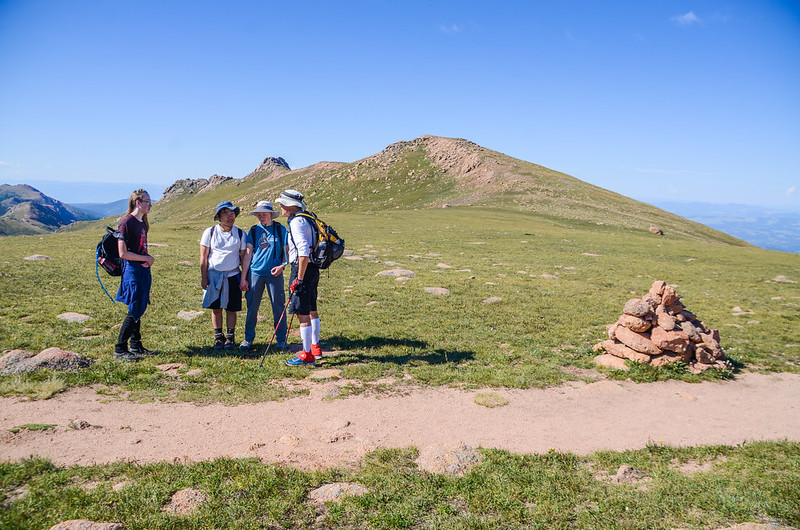


The 12,750' saddle at northwest slopes
There is a large cairn beside the road. Looking southeast from this saddle, you can see the top of Pikes Peak, and you can also vaguely see most of the rest of the route. From here to the top of the mountain, it is still more than 3 miles away;

Near the 12,750-foot saddle, viewing much of the remaining route. From this point, it’s 3 more miles of hiking to reach the summit.
We rested here for about ten minutes before continuing towards the top of the mountain. After that, the trail turned to a relatively flat road and headed east on the gentle slope of Devils Playground.
10:00 There is a viewing point on the left ridge, with coordinates N38° 51.927' W105° 04.540'. Take the left trail and go to the ridge to the north, overlooking the Pikes Peak Toll Road with countless hairpin bends and Glen Cove - PPIHC, Ski Area - PPIHC on the roadside; PPIHC (The Pikes Peak International Hill Climb) is Pikes The Peak International Hill Climb, also known as the "Cloud Race", is an annual car hill climb to the top of Pikes Peak in Colorado, United States.

Devils Playground Trail


Overlooking Pikes Peak Toll Road from the viewpoint facing north
The lake in the distance to the north is the North Catamount Reservoir.

Overlooking Pikes Peak Toll Road from the viewpoint facing north
10:15 Arrive at a gap in the middle of a large rock formation, coordinates N38° 51.781' W105° 04.298', elevation 12,860 feet/3,920 meters, 3.8 miles/6.12 kilometers from the trailhead;
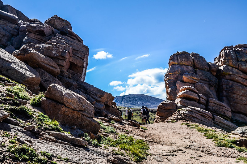
Portal to the Devils Playground
Blue Truck calls the stacked rock formations "Pancakes," and they do look somewhat like them. Passing by, I was a bit hungry, so it would be great to have a few "Pancakes." If not, just looking at those rocks would be nice!


Looking back through the 'gateway' in the rocks~Pancake
After passing through the gap in the rock formation, we are almost at Devils Playground; looking southeast from the gap, today's destination, Pikes Peak, stands about 2.5 miles/4.02 kilometers away.

Devils Playground Trail
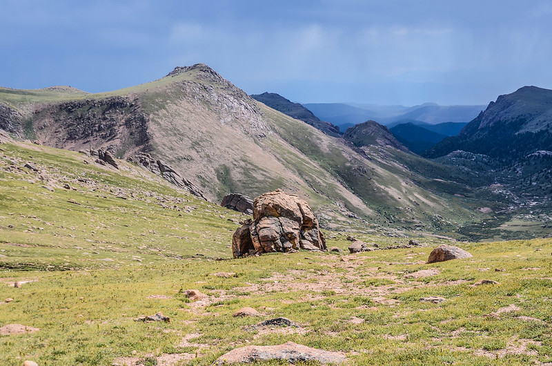

Up through the rocks
10:22 Arrived at the Devils Playground parking lot, coordinates N38° 51.800' W105° 04.131', altitude 12,945 miles / 3,946 meters, approximately 3.9 miles / 6.28 kilometers from the trailhead;
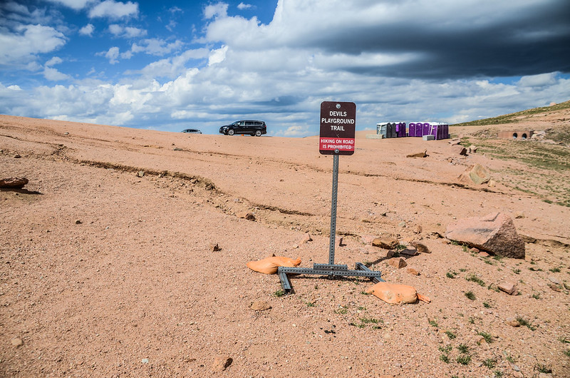
Devils Playground
The parking lot is quite large and has portable toilets. There's a Devils Playground Trail running from the parking lot that leads to Devils Playground Peak to the northwest.
At 10:24, from the northeast corner of the parking lot, cross Pikes Peak Toll Road to the north side of the road. Follow the hiking trail on the east side of Pikes Peak Toll Road southeast towards the summit. The crossing point is located at N38° 51.832' W105° 04.087', with an elevation of 12,936 feet/3,943 meters, approximately 4.0 miles/6.44 kilometers from the trailhead. After crossing Pikes Peak Toll Road, there's a sign next to the trail. After reading it, I learned the origin of the name: "Devil's Playground so named because of the way lightning jumps from rock to rock during a thunderstorm."

Devils Playground
The trail runs south along the wide trail at the foot of the mountain on the left.

Looking back at the route leading to Devils Playground, The Pikes Peak Road is in the foreground

Near 12,950’ along the road, Follow the trail on the left side of the road as you approach point 13,363’
10:43 Arrive at Bottomless Pit Viewpoint, coordinates N38° 51.440' W105° 03.823', elevation 12,940 ft / 3,944 m;


Bottomless pit viewpoint

Bottomless pit viewpoint
After passing the Bottomless Pit viewpoint, the trail continues south, around a hill on the left, and then continues southeast.

Bottomless pit viewpoint

Devils Playground Trail

At 13,150’ on the left (northeast) side of Point 13,363’. Follow the trail back to the road and past two more road corners
Soon after descending to the foot of the 13,363’ peak (some call this peak Little Pikes), walk southeast along the trail.

Devils Playground Trail
At 11:00, the hiking trail begins at the foot of the mountain on the left side of the 13,363’ peak and gradually ascends to the southeast, at which point the remaining hiking trails come into full view.

Devils Playground Trail
11:13 After rounding the 13,363’ peak, we arrived at the saddle between the 13,363’ peak and Pikes Peak, with coordinates N38° 50.984’ W105° 03.426’ and an elevation of 123,130 feet / 4,002 meters.

The saddle between Pikes Peak & Point 13,363'
The right side of this saddle is adjacent to Pikes Peak Toll Road, and there are some remnants of early mining equipment.
At 11:44, leaving the saddle, we followed a still-clear trail along the sharp bend of Pikes Peak Toll Road up to the large platform below the rocky slope of Pikes Peak, coordinates N38° 50.706' W105° 02.959', elevation 13,500 ft / 4,115 m;

Pikes Peak Toll Road

Devils Playground Trail

The platform at the bottom of the final stretch


Bighorn sheep
Looking up from the platform, one can see the remaining 0.5 miles of steep, rocky slope, which requires climbing about 600 feet/183 meters.

The final stretch below the summit
After leaving the platform, enter the large rocky slope and climb up the cairn piles stacked by hikers. In some sections, the cairn piles branch off, so you have to carefully find the path.

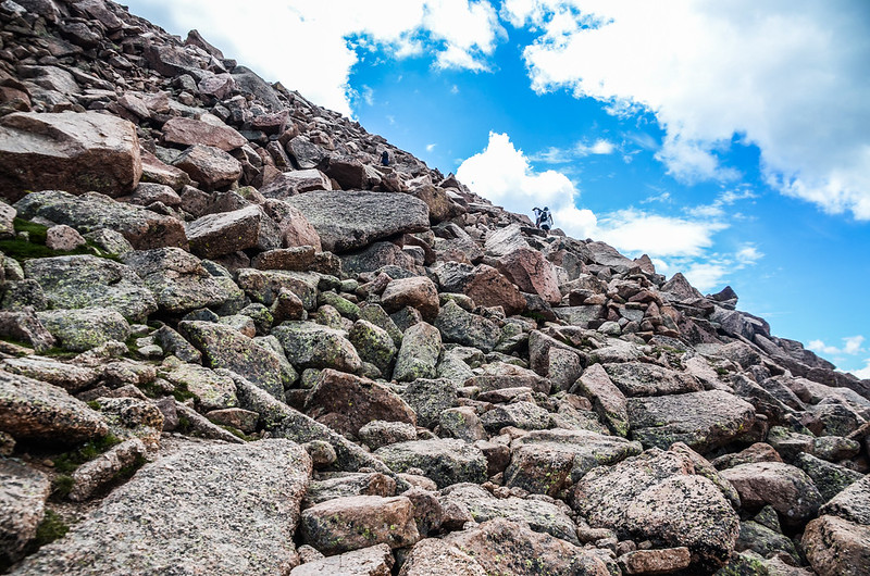
Crossing the upper scree field

View southwest at Bighorn Reservoir from the rock slopes below the summit

Rocky terrain throughout hike on Devils Playground route
12:47 Arrived at a sharp bend in the road, we are almost at the top of the mountain, coordinates N38° 50.492' W105° 02.773', altitude 14,034 feet / 4,278 meters;

Just below the summit on a corner of the road
From the road corner, cut a gentler gravel slope to the upper left and continue climbing to the top of the mountain.

Crossing the upper scree field
12:50 After six hours, we finally reached the summit of Pikes Peak, about 6.6 miles/10.62 kilometers from the trailhead;

The view from Pikes Peak summit
While taking a photo with me, Blue Truck happily pulled me aside and told the tourists, "Our combined ages are 152."

Taken on May 28, 2005, at the mountaintop marker. The child I held in my arms then is Beibei, who accompanied me to the summit today.


Me & Blue Truck on the summit


New summit sign at Pikes Peak

The benchmark on the summit of Pikes Peak
The vast mountaintop platform has been completely transformed, and the scenery is entirely different from what it was more than a decade ago. The original stone-built visitor center has been demolished and rebuilt into a modern and stylish building.

Summit house (Taken in 2005.05.28)

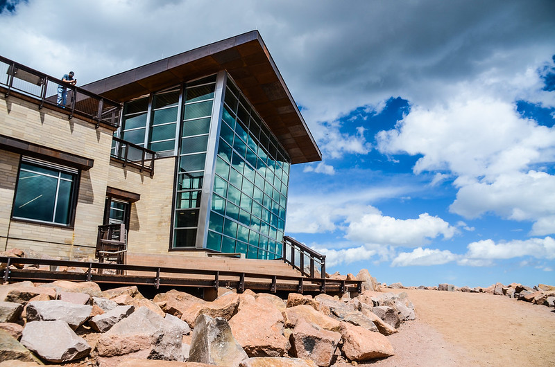

Pikes Peak summit visitor center
After taking photos at the official mountaintop marker, we went to the visitor center to rest and have lunch. Of course, we had to try the famous donuts!

The high altitude donuts at Pikes Peak Summit House

View north from the summit of Pikes Peak

Looking down to Lake Moraine from the summit(To the southeast)

View north from the Pikes Peak summit

The view from Pikes Peak summit

“America the Beautiful ” plaque on thesummit of Pikes Peak (by Katharine Lee Bates)
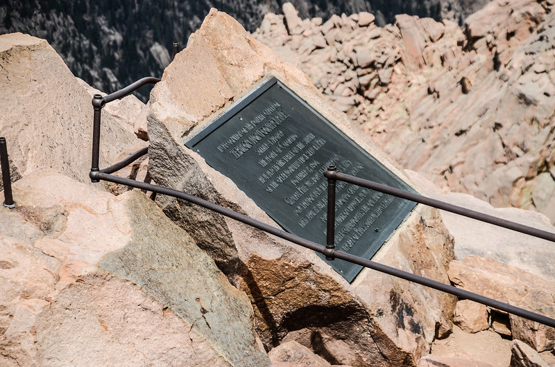
Zebulon Montgomery Pike Marker on the summit of Pikes Peak

Looking over the cog rail line at the summit of Pikes Peak, Colorado
13:50 After resting, we walked around the top of the mountain and then descended the same way.

Crossing the upper scree field
15:33 Returned to Devils Playground and continued down the same route.

Devils Playground Trail
At 17:50, we returned to the parking lot at the trailhead, and after a quick change of clothes, we took a Blue Truck down the mountain to go home.
沒有留言:
張貼留言