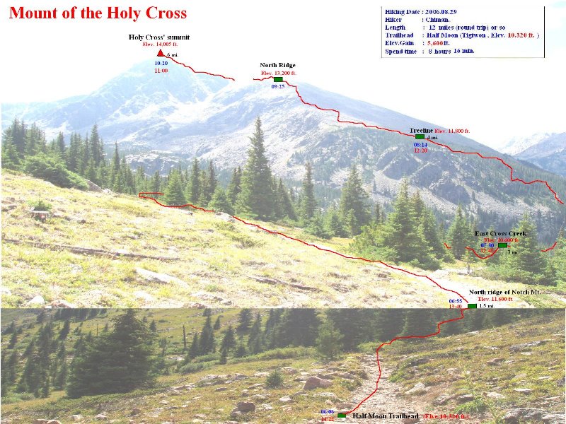
搜尋此網誌

2006/08/31

Mount of the Holy Cross(聖十字架山)攀登記(2006.08.29)

Hiking Route 


科羅拉多最響譽的14ers--Mount of the Holy Cross(海拔14,005/ 4,269公尺,屬於Sawatch Range,在14ers中排序為第51),是以它東北面一個積滿白雪的十字架形狀的峽谷而出名,這十字架是由1,500呎高的垂直峽谷和750呎長的岩溝水平交叉,由於峽谷和岩溝積滿白雪,遠望就像一座巨大的十字架;但由於自然的風化侵蝕,使得此十字架在近一百年來越來越不清晰。此十字架在1869年首度被發現,20世紀初期是基督教徒朝聖的目的地,直至今日仍擁有其燦爛的光榮歷史。

Mount of the Holy Cross. as seen from Spalding's summit view

Mount of the Holy Cross (Photo by Gareth)


此山在滑雪勝地Vail西南方14哩處,距丹佛約100哩左右,若要清楚的看見如其山名的十字架,就必須攀登在其東邊的另一座山Notch Mountain(13237 ft / 4035 m),在此山頂上最能清楚的看清此天然的十字架。

Mount of the Holy Cross一度列為國家的歷史遺址(U.S. National Monument),但後來因為遊客太少不敷成本而於1950年才撤銷。

攀登Mount of the Holy Cross最常走的一般路線是由Half Moon (Tigiwon) Trailhead啟登的North Ridge,全程來回約11.5(18.4公里),爬升高度約5,600( 10,320 ft .~ 14,005 ft .),大約1,707公尺,攀登等級是Class 2,算是不輕鬆的一段行程。

該山我於2006.08.29去攀登,由於離家車程要兩個多小時,所以凌晨兩點多出門,沿I-70州際道路西行,過滑雪勝地Vail不久於Exit171出口接US 24南下,後右轉Tigiwon road到登山口,時天已微亮。

06:06 登山口出發(海拔10,320/3,146公尺)。出發不久遇一自然保護區入山登記處,此地屬於Holy Cross自然保護區(Holy Cross Wilderness),自行登記後將一份資料( Wilderness Registration Card)投入箱子內。

Half Moon Trailhead


沿維護完善的步道緩升朝西北前進。

Half Moon Trail


剛開始步道是在森林間穿梭,偶而透空處可看到紅色晨光灑落Notch Mountain山頂。

Sunrise alpenglow on Notch Mt.(13,237 ft.)


06:55 行約1.5哩後抵稜線接Half Moon Pass,此地是Notch Mountain(13237 ft / 4035 m)的北稜,海拔11,600呎,Notch Mountain就在左邊。此時紅色晨曦正灑落西邊Mt. Jackson (13,670')等山頭上。


Mt. Jackson (right, 13,670') at sunrise, from the north ridge of Notch Mt.


越過後Notch Mountain的北稜後步道轉向西,就在Notch Mountain的西北坡緩下。

07:10 來到一個展望點,隔著East Cross Creek看見Mount of the Holy Cross和它的整個北稜,Mount of the Holy Cross高傲的挺立在諸山頭的左側,看起來就是那麼神聖不可侵犯,此地海拔約11,400呎。

Mt. of the Holy Cross at sunrise(Taken from Half Moon trail)


過此點後步道轉向南,並沿著一連串的之字形步道朝East Cross Creek陡下。當下降將抵East Cross Creek時,會進入較密的森林,而此時在步道兩側都有營地可供露營。

07:30 East Cross Creek,海拔10,600呎,距登山口約3哩,從小溪上的石橋橫過後開始循Holy Cross的北稜上攀,一開始會經過幾處亂石坡,之後便在森林中穿梭。

East Cross Creek


08:14 出森林線,海拔11,800呎。視線豁然開朗,Holy Cross的北稜呈現眼前。

Looking up Holy Cross' north ridge from treeline(11,800 ft.)


08:24 Holy Cross山頭從北稜的稜線冒出,海拔12,100呎。

Looking up Holy Cross' summit & north ridge from above treeline(11,800 ft.)


之後的步道就消失在亂石堆中分辨不出,幸好在亂石堆中每隔不遠的距離便有很高的石堆(cairn)指引,只要順著石堆朝最高點上攀就對了。

Holy Cross with rock cairn in foreground


一路上太陽很大,岩石堆不好爬,空氣很稀薄,很累!偶而行走在稜上往左下一看,深不見底的峽谷由山頂一瀉而下,深谷裡偶而可見碧藍的小湖Bowl of Tears(還是嘉明湖形容的較詩意--天使的眼淚)Holy Cross山頭在峽谷的另一邊向著登山客招手。

Cross Creek valley from North Ridge

Looking down the West Cross Creek from Holy Cross trail

The cairns and Mt. Jakson(R)(Taken about 12,600 ft. of north ridge of Holy Cross)

A view of the summit from the crest just below the summit ridge on the way up

North Ridge of Holy Cross

Holy Cross' summit from north ridge


09:25 攀抵Holy Cross的北稜頂,海拔13,200呎。此時沿著稜線又可見一清晰的小徑往南延伸直抵Holy Cross的山腳下,沿此小徑前進,沿途往南可遠眺Elk Mountains的幾座14ers

On the north ridge of Holy Cross

Angelica Couloir from the North Ridge


09:40Holy Cross的山腳下,海拔13,400呎,左邊有一小峽谷直瀉谷底。

Looking west from The ridge runs into the summit block of Holy Cross at 13,400 feet


Looking southwest from The ridge 


轉向左邊朝東直上就是山頂,路徑又不見了,只好又在亂石堆中手腳並用,努力往上爬。高度又更高了,空氣更稀薄了,老實說,很累!

Looking down North Ridge from above the Angelica Couloir

The final summit pitch seen from 13,700'


10:20 Finally!終於攀上山頂,海拔14,005(4,269公尺),這是我今年在科羅拉多的第914ers


On the summit of Holy Cross


Holy Cross的山頂蠻寬廣的,在山頂最高岩石上崁有一個Benchmark(水準點)的銅標。

Summit of Mt. of the Holy Cross(Elev. 14,005 ft.)

Summit mark of Mt. of the Holy Cross


今天天氣晴朗,展望極佳。不久一個年輕人冒出山頭,他是我今天遇到的第一位山友,他說是從Angelica Couloir(好詩意的名字)攀岩上來的,難怪一路上我都不覺有人跟來。

從山頂往東可遠眺Notch Mountain上的那間有名的石屋The Notch Mountain Shelter(看此山十字架最佳位置)

 Notch Mt. from summit of the Holy Cross,The Notch Mt.Shelter can just be seen to the middle.

 Notch Mt. from Holy Cross' summit


往東俯瞰Bowl of TearsLake Patricia

Bowl of Tears from  Mt. of  the Holy Cross' summit

 Lake Patricia and the East Cross Creek valley from the summit of Mt of The Holy Cross


往東遠眺Grays and Torreys Peak兩座14ers


往南遠眺科州第一、第二高峰及Elk Mountains的幾座14ers

Summit view from Mt. of the Holy Cross looking south( Mt. Massive & Mt. Elbert)

Summit view from Mt. of the Holy Cross looking southwest

Summit view from Mt. of the Holy Cross looking southwest

Summit view from Mt. of the Holy Cross looking south

Peak 13,831' from Holy Cross' summit looking South

Summit view from Mt. of the Holy Cross looking west

Summit view from Mt. of the Holy Cross looking west


11:00 下山,途中又遇到幾位山友正要上山。

 Notch Mt. from the north ridge of Holy Cross


12:20 過森林線,進入松林中。

12:45 下抵East Cross Creek。開始沿Notch Mountain西北坡爬升。

13:14 爬完之字形小徑後抵11,400呎展望點,步道右轉朝東沿Notch Mountain北坡緩升。

 Mt. of the Holy Cross (Taken from Half Moon trail)


13:40 Half Moon PassNotch Mountain的北稜,轉右越過稜線朝東南下山。

Mt. Jackson (right, 13,670') from the Half Moon Pass

Notch Mt. from Half Moon Trail


14:22 返抵登山口,整裝開車回家,這時才看清楚一路沿著Tigiwon road的兩側都是高大的白楊木(Aspen),來年9月該找個時間來此欣賞白楊木。


2006/08/17

輕鬆登頂14ers--Mount Sherman順登13ers--Mount Sheridan(2006.08.15)

Mt. Sherman as seen from the viewpoint along US-24,south

Mount Sherman from Fairplay 

Mount Sherman海拔14,036(4,278公尺),是科羅拉多州第46高峰,屬於Mosquito Range;該山大約位在Fairplay Leadville兩市之間,躺臥在另一座14ers Mount Lincoln南邊約8哩處,距其西北的小鎮Leadville7哩之遙。Mount Sherman 是一座緩坡、沒有陡峭地形、山頂又很寬廣平坦的山岳,加上它的連稜也有幾座高度相近的高山,所以遠看很難分辨出來。也因為它的緩坡易爬,大部分有意征服14ers的登山客都把這座山當作入門山岳。


攀登Mount Sherman 較常走的路線有兩條,各有其特色。通常一般登山客都是從東邊經小鎮Fairplay,走 Fourmile Creek Trailhead,即所謂Southwest Ridge Route,從此登山口起登沿途會經過幾個老礦區,全程約2.7(4.32單程),爬升高度約2,100(640公尺),攀登等級Class 2;另一條路線是從西邊經小鎮LeadvilleIowa Gulch Trailhead,即所謂West Slopes Route,全程約2.25(3.6單程),爬升高度約2,100(640公尺),攀登等級Class 2。兩條路線交會於距山頂約一哩處之Mount Sherman南稜,然後沿著維護良好的小徑直達山頂。從Mount Sherman往北走可順登Gemini Peak(13,951)Dyer Mountain(13,855),往南則可攀登Mount Sheridan(13,748),這幾座山都是蠻有名的13ers


繼上週六爬完Mount Massive後,帶著女兒怡如和小外孫信恆Matthew來爬此座較簡單的14ersMatthew剛滿7歲,這是他的第一座14ers。我們當天凌晨四點多從家裡出發,走US 285公路,經Fairplay Fourmile Creek Trailhead,我們計劃走Southwest Ridge Route上山。


06:40 抵登山口Fourmile Creek Trailhead,海拔12,000(3,658公尺) ,好冷,約攝氏5度左右,怡如冷的直發抖。

Trailhead(below Dauntless Mine)


06:50 登山口出發。先經過一座鐵柵門,後沿步道緩上,不久到一礦區Dauntless Mine,海拔約12,300呎,整座Sherman呈現眼前,繞過礦區續行。

 Mt. Sherman(Taken from just above Dauntless Mine)

Hiking route


07:18 抵一水塘海拔約12,500呎,怡如和信恆Matthew取右直攻Mount Sherman,我則取左先登Mount Sheridan


一般登山客來此主要是攀登Sherman,甚少攀登Sheridan,所以Sherman的步道清晰好走,而Sheridan則沒有步道可行,只有朝山頂抓住目標,自尋路徑上登。由於一路不是亂石堆就是碎石坡,走來甚是費力,不到400公尺 的爬坡竟費了50分鐘,且爬得上氣不接下氣。


08:08 登頂Sheridan,海拔13,748呎。Sheridan的山頂成東西長條形長廊,山頂展望極佳。


 On the Sheridan's summit(Mount Elbert & Massive are in the background) 

On the Sheridan's summit(Mount Sherman is in the background) 

The East summit of Sheridam

The west summit of Sheridan


遠眺科羅拉多第一、第二高峰Mount ElbertMount Massive並立西方,這兩座高山分別在714日和三天前去攀登過,現在看起來備感親切。

Looking towards the Sawatch Range from Sheridan's summit.Elbert and Massive dominate the view

Twin Lakes from Sheridan


觀光小鎮Leadville則在西北方不遠處,北邊那寬平似龍背的山脊即是Mount Sherman

Looking towards Leadville from Sheridan's summit.Mt. of the Holy Cross is in the distance right

 Mt. Sherman (Taken from the summit of Mt. Sheridan)


08:20 下山,循Sheridan的北面山坡而下。

08:40 下到ShermanSheridan間的鞍部,此地海拔13,140呎。怡如和Matthew就在不遠的往Sherman山頂的山坡上。

 Mt. Sheridan(Taken from the saddle)

 Mt Sherman,Summit Ridge

 Mt. Sherman(Taken from the saddle)

 Iowa Gulch(Taken from the saddle)


09:10 趕上怡如和MatthewMatthew看起來狀況還不錯,接下來便祖孫三人同行,登山小徑沿著Sherman的南稜而上。

Don't give up ! Baby.

Ruth and Matthew ascends the SE slopes of Sherman

Ascending Sherman's south ridge

Narrow ridge near the summit

 Yes you can play football on the Mt Sherman summit


10:15 抵達真正的山頂,海拔14,036(4,278公尺)


Sherman的山頂就像好幾個足球場般寬敞平坦,展望一級棒,Tenmile and Mosquito RangesSawatch Range、和Front Range14ers不下十幾座在此盡收眼底。祖孫三人就在此一邊用餐一邊賞景。

The broad summit of Mt. Sherman(toward south)

The broad summit of Mt. Sherman(toward north)

Looking east from the summit of Mt. Sherman(White ridge)

Dyer Mt.& Gemini peak from the south ridge of Sherman

The north ridge of Sherman, Gemini Peak are behine

Looking NE from the summit of Mt. Sherman

View from Mt. Sherman's summit (North)

 Looking towards the Sawatch Range from Sherman's summit.


11:00 下山

Descending Sherman's south ridge

Descending Sherman's south ridge

Descending the last boulder terrain

 Hilltop Mine and Mt. Sheridan

 Dauntless Mine and Fourmile Creek Trail, Sheep Mt. in the background


13:10 回到登山口,Matthew也驕傲的完成他的第一座14ers。倒是他媽媽--勉強撐到登山口。

Almost finish this hike, I'm proud of Myself !

Oh , My God ! How great hike !


2006/08/15

攀登科州第二高峰--Mount Massive(2006.08.12)

科羅拉多最高峰Mt. Elbert & 第二高峰Mt. Massive ( from county road 11)

科羅拉多最高峰Mt Elbert & 第二高峰Mt. Massive ( from county road 11)


Mt. Massive海拔14,421(4,396公尺),是科羅拉多第二高峰,也是美國本土48州中第三高峰,僅次於加州的Mt. Whitney( 14,497 ft / 4,419 m )和位在其南邊的Mt. Elbert( 14,433 ft / 4,399 m )。它的山名已說明一切,Massive一共有五個超過14,000呎的山頭聳立在3哩長的山脊上,在美國本土是最多14,000呎以上高山的山塊。Mt. MassiveMount Elbert位在小鎮Leadville的西南邊11哩處,兩座科州的第一和第二高峰和許多座14ers都是屬於Sawatch Range,他們形成Leadville西南一條美麗壯觀的空中走廊,也是Leadville的一座天然屏障。

Mt. Massive (Taken from Northeast ridge of  Mt. Elbert)


Mt. Massive( from county road 11)

Mt. Massive as seen from south of Leadville


第一個登上Mt. Massive的是1873年的Henry Gannett。打著科羅拉多第二高峰之名,在夏日的週六、週日,山頭往往擠滿登山客。

1970年代,一群熱愛Mt. Massive的登山客一直認為Mt. Massive才值得稱上科羅拉多第一高峰,但是在其南邊的Mount Elbert硬是比它高了11( 3.4公尺 ),所以發起了一個運動,就是在山頂上堆砌石塊,試圖使其高度超越Mount Elbert;此舉引起Mount Elbert迷採取反制行動,就是登上Mt. Massive時順手摧毀山上的石堆,最後才使Mt. Massive迷放棄其企圖,Mount Elbert終究保住科州第一高峰的名號。

攀登Mt. Massive的路徑因難易度之不同而有很多條路線,但一般登山客最常走的也是較容易的路線有兩條;最傳統的標準的登山路線是所謂的Mt. Massive Trail,登山口是在一般車輛都可到達的Mt. Massive Trailhead,由此起登全程來回約13.75哩,爬升高度4,500( 10,080 ft .~ 14,421 ft .) ,攀登等級為Class 2,一般登山客稱此路線為East Slopes Route。全程路線大都循此山東坡而上,安全好走,惟距離稍長。另一路線是西南坡路線Southwest Slopes Route,此路線登山口在上一登山口再往前行約2.5哩到達N. Halfmoon Creek Trailhead,但此2.5哩的小路極為崎嶇難行,沒有性能良好的四傳車輛是無法到達的。若由此起登,全程來回約7.5哩,爬升高度3,950( 10,500 ft .~ 14,421 ft .) ,攀登等級為Class 2,一般登山客稱此路線為Southwest Slopes Route。由此路線起登距離較East Slopes Route為短,但坡度較前者為陡,全程大多在35度的陡坡爬升。


Southwest Slopes Route(Overlook from Mount Elbert)


2006.08.12 George和我繼上週爬完Quandary Peak後再來爬此山我們走的是Southwest Slopes RouteGeorgeJeep果然性能良好,反倒是我這個搭車的,顛簸得整顆心都像要蹦出來的感覺。我們清晨五點從Thornton出發,到登山口約七點十分左右,因這個登山口前半段在714日 攀登Mount Elbert時已走過,所以很順利的到達。停好車稍作準備便出發攀登號稱科州第二高峰。

07:22 登山口出發,海拔10,500(3,200公尺)

N. Halfmoon trailhead


一開始步道蠻寬敞的,且是在松林中穿行緩升,偶而看到幾頂露營帳。


07:50 出森林,開始在矮柳樹叢中穿行,此地海拔約11,200呎,距登山口約1.2哩左右。

從 N. Halfmoon Creek西望,此處距登山口約1哩;照片後頭是 Mt. Oklahoma;登山步道穿過松林後沿右側山坡爬升。


07:57 出現一片草原,直行可達North Halfmoon lakes,我們取右上。之後山徑變小,且在小樹林、草原、亂石坡中大致朝西北方向穿行爬升。

 樹林前為上山岔路


08:39 越過亂石坡,轉向東北,抵一開闊點。

View to south from Southwest slopes trail

Mt. Massive's Southwest slopes trail


此地海拔約12,200呎,東北方是一巨大岩石堆,整個山坡開滿野花,亂美的。從開滿野花的山坡朝向東北岩石堆方向橫切而過,抵岩石堆後轉向左邊朝北邊陡升。好陡,亂石不好走,回望西南邊Mount Elbert及幾座Sawatch Range的高山高聳入雲。

View to south from Southwest slopes trail

View to south from Southwest slopes trail


09:22 右邊一叉路,沿山溝爬升直抵山頭稜線鞍部,看起來碎石坡怪難走的,還是往左陡上,循傳統路線前進。

Ascending the West Slopes Route of Mt. Massive

仰望Mt. Massive's Southwest slopes trail

 Halfmoon Lakes(Looking west from the summit ridge)


10:17 好不容易爬升到一群巨大岩壁(左側)下,海拔大約14,100公尺,已接近稜線。

 A closer look at the terrain above the trail near summit ridge

 Looking southwest towards South Massive from the Southwest trail


10:25 通過一巨石,照張相。


10:30 上抵Summit Ridge,海拔約14,200呎。

 Looking southwest towards South Massive from the summit ridge


10:33 銜接東稜標準路線(East Slopes Route)上來的交叉口,海拔14,250呎。

Intersection of East Slopes trail & Southwest Slopes trail


之後即在Summit Ridge沿稜線朝峰頂北行,登山客不少,整個Summit Ridge被雲霧籠罩,看來今天又是個展望不佳的Hiking day

 Approach the summit ridge

 Summit of Mt. Massive

 Summit of Mt. Massive


10:55 終於登上科羅拉多第二高峰Mt. Massive,海拔14,421(4,396公尺),山頭都是登山客,但因霧濃,視野不佳。週遭山頭似披上一層薄紗,也分辨不出哪座山頭。山頂附近一群大約一、二十個14ers的志工(CFI)正在徒手搬石鋪設步道,心存感激。

On the Summit of Mt. Massive

CFI just maintain the trail

The summit ridge

 Looking back(south) at the summit ridge

 Halfmoon Lakes(Looking west from the summit of Massive)

 The north ridge to Massive Green and Massive (Taken from the summit of Massive)


11:25 下山

 The west slope of Massive

 The summit ridge

 The summit ridge

 The summit ridge


11:50 抵東稜標準路線(East Slopes Route)叉路口,取右循原路下山。

12:08 通過一群巨大岩壁下(右側) ,海拔大約14,100公尺,取左陡下切。

12:52 巨大岩石堆,轉右橫越長滿野花的大草坡。

 Wildflower along the trail

 Mushroom


13:55 返抵登山口,整裝回家。George,辛苦你了!兩個多小時的車程。