Grays and Torreys seen from Stevens Gulch
Grays Peak & Torreys Peak via the Kelso Ridge route
Grays Peak(14,270呎/4,350公尺)是科羅拉多州高度排第九的高山,介於Clear Creek County和 Summit County兩郡間的高點,它也是Front Range和美國大陸洛磯山脈分水嶺(Continental Divide)的最高峰。
一般登山客爬此山最容易的登山路線是由Stephens Gulch Trailhead(11,280呎/ 3,438公尺 )起登,難度為Class 2。登上此山後沿其北稜下切約570呎( 174公尺 )抵達一鞍部,再往北爬升567呎( 173公尺 )登上另一座不到一哩、排名第十一的14ers-- Torrey Peak(14,267呎/ 4,349公尺),然後循原路下山,或由鞍部取捷徑下山,全程來回約8.25哩( 13.2公里 ),一天內可連攻兩座14ers。
首登Grays Peak和Torreys Peak的是一位植物學家Charles C. Parry,他以他兩位很有名的同事、也是植物學者Asa Gray和John Torrey之名分別為這兩座山命名,而Asa Gray和John Torrey真正看到此兩峰卻是在11年後的1872年。
要攀登此兩座14ers.若從丹佛出發取道I-70州際道路往西行約50哩,由Exit 221 Bakerville出交流道,再沿Stevens Gulch Road南行約3哩可抵登山口Stevens Gulch Trailhead。但這三哩的小路是有夠難走的,非性能良好的四傳車不建議進去。
Torreys Peak sunrise(from the Forest Road 189)
此兩峰我於2006年夏季來爬過兩次;第一次是當年7月22日 個人單攻,走上述傳統路線,經由Grays Peak再攻Torreys Peak,然後退回鞍部取捷徑下切,來回8.25哩共費時6小時40分鐘。時隔一個多月,適山友Louis遠從明尼蘇達(Minnesota)來,便帶著女婿家人和此地山友,陪同Louis於9月4日 二度造訪此二峰,但此次我個人單獨走Torreys 東稜的Torreys Peak - Kelso Ridge路線,此路線難度等級為Class 3和Class 4,極為陡峭,且有一段是"knife-edge",極為危險。此路線是先上到Torreys Peak後,再攀登Grays Peak,然後循傳統路線下山。此次全程雖只7.25哩,但卻花了八個多小時。以下紀錄即為Torreys Peak - Kelso Ridge路線之紀錄。
0650 登山口(海拔11,280呎)出發,先過一鐵橋後沿維護良好的寬敞步道緩升,右側是海拔13,164呎的Kelso Mountain,步道就在其山腳下盤旋上升。
Grays Peak trail
Kelso Mt. as viewed from the Grays Peak Trail.
Stevens Gulch
Stevens Gulch trail
0800 行約1.5哩後抵一登山資訊牌(Information sign),在此西望Grays和Torreys雙峰矗立眼前。之後步道變小,偶而要在亂石中跨越前進。
Grays (L)and Torreys(R) seen from Stevens Gulch(from 1.5 miles into the hike)
Most of Kelso Ridge sseen from the Grays peak trail,the Torreys' summit is on the left
0818 抵傳統步道和Torreys Peak - Kelso Ridge路線分岔,此地海拔12,100呎,距登山口約1.75哩。直上是Grays Peak,山友們由此上Grays,我則取右往Kelso Ridge攻Torreys。
0824 抵Torreys Peak和Kelso Mountain間鞍部,發現有一間小而老舊的以前採礦留下的木屋,此地海拔12,300呎,向西仰望Torreys山頂及稜線,的確陡峭,將有一番苦戰。
Kelso ridge & Old mine shack
From the saddle, It's difficult to see the exact route but it gives you an idea of the terrain
左向Torreys Peak - Kelso Ridge往Torreys攀爬。自此路徑時而清楚、時而不明;時而在稜線左側、時而在右側;時而易走、時而險峻。總之你不可心急,也不可太固執,當你發現你前面的路徑實在太險峻時,不妨回頭再找找看,或許你是錯過了某一叉路。
The terrain of Torreys Peak-Kelso Ridge trail
This photo shows some of the steep terrain
Grays Peak from the Torreys-Kelso Ridge route
Looking back down the route
10:24 經過兩個小時的奮戰終於來到了所謂的"knife-edge"(海拔14,000呎),說他是「刀棱」實不為過,薄薄的一片瘦稜,登山客必須跨坐其上慢慢往前移動,右側是有名的深谷Dead Dog Couloir,右側也是深不見底的斷崖,跨坐瘦稜上,雖身經百戰仍不免有點怕怕。
Crossing the Knife-edge(Taken from above the white-rock looking back down the route)
1030 通過"knife-edge"後,擋在眼前的是一大所謂的white-rock巨大大理石。
The white-rock
越過此大石後即抵達Dead Dog Couloir的頂部,此地海拔14,100呎,距峰頂已不遠,回首來時路清晰可見。
Looking back down the route from Torreys' summit
1040 再經過一段鬆散的碎石坡後終於抵達Torreys Peak峰頂(海拔14,267呎),距登山口約2.75哩(4.4公里),我竟爬了將近四個小時。
On the summit of Torreys Peak
山頂登山客不少,展望極佳;往北遠眺,洛磯山國家公園的另一座14ers--Longs Peak清晰可見;南邊半哩之遙的下一目標--Grays山頂、半山腰、鞍部也是密密麻麻都是登山客。
Longs Peak seen from Torreys' summit(M), Indian Peaks is in the right.
View to East from Torreys peak
Summit view from Torreys Peak looking northeast
Grays Peak from Torreys' summit
Looking down Stevens Gulch from Torreys' summit
1050 取道Torreys南稜下山,往Grays邁進。
1115 下到Grays--Torreys鞍部(海拔13,700呎),開始往Grays Peak爬升。
Looking back up Torreys' summit while descending it
Looking up Grays Peak from Torreys-Grays saddle
1130 於Grays Peak北坡與Louis等山友相遇,合照後續行。
Torreys Peak from Grays Peak
1140 登頂Grays Peak(海拔14,270呎),稍後女兒偕外孫信恆(Matthew)也登頂,三代同登14ers,應是美事一樁。
On the summit of Grays Peak
1230 在Grays山頂用餐,山頂視野佳,往東、往南又遙望數座14ers後祖孫三人開始下山。
Quandary Peak seen from Grays' summit(M),Lincoln group is in the left(四座皆為14ers)
Looking east from the summit of Grays Peak
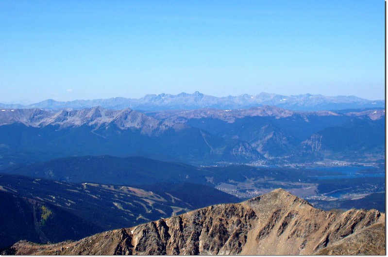
Looking west from the summit of Grays Peak, Mt.of the Holy Cross(14ers) is in the distance center.
半山腰遇一中學生騎著獨輪車在走路都有點難的陡峭山路上跳來跳去,真服了老美的冒險、挑戰勇氣。
One wheel biker
Mountain goat
Looking up to the saddle from the NE Slope on Grays
An interesting finger of rock beside the route of ascending (13,200 ft.)
Kelso Mt. as viewed from the Grays Peak Trail.
1420 下達傳統步道和Torreys Peak - Kelso Ridge路線分岔點。
1530 回抵登山口,大夥到齊後打道回府。
Grays Peak Trailhead
沒有留言:
張貼留言