
Black Canyon National Park South Rim entrance sign
Crested Butte賞花行第三天早上再到Teddy's Trail和East River Trail走走後便驅車前往Black Canyon National Park,該公園早於2011年秋天去過,但當年只遊覽南緣(South Rim)沒時間遊覽北緣(North Rim),此趟特地繞道舊地重遊,除再到南緣(South Rim)一遊外,順便到北緣(North Rim)參觀。
我們計畫7月9日下午抵達公園南緣參觀,當晚住宿在公園西北角的Delta,第二天進入北緣參觀後再開車返回丹佛。
行車資訊:
早上在Crested Butte再去一趟East River Trail後開車回到CO-135 公路左轉朝Gunnison
南行,行約25.3哩抵Gunnison接到US-50 ( Tomichi Ave)向右轉朝Black Canyon National Park西行,繼續開在US-50 W上西行約56.7哩後於CO-347 N向右轉北行,再行約5.4哩先經過路右國家公園入口意象招牌;

Black Canyon National Park South Rim entrance sign
再行0.2哩經過Entrance Station,購票或出示Annual National Parks Pass進入園區。
Black Canyon National Park South Rim entrance sign
再行0.2哩經過Entrance Station,購票或出示Annual National Parks Pass進入園區。
----------------------------------------------------------------------------------------------------
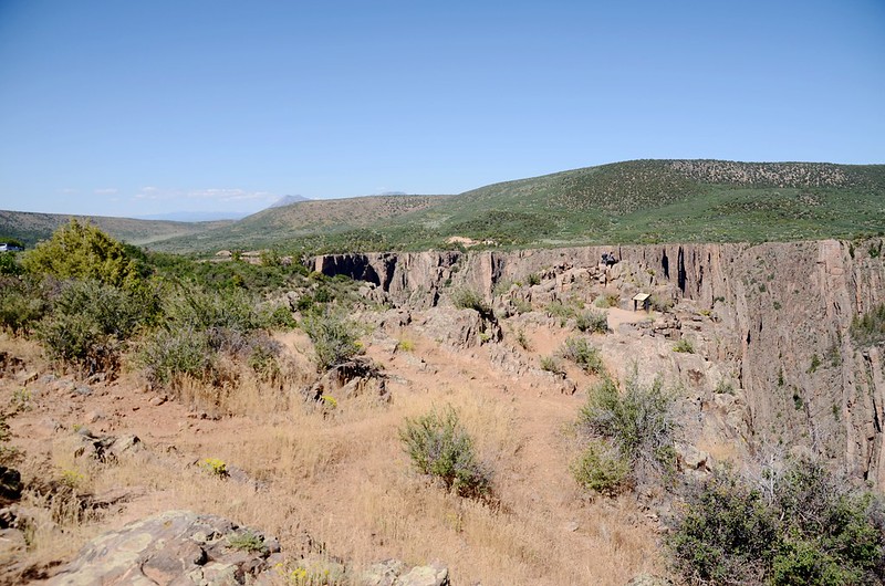
Gunnison 黑峽谷國家公園位在科羅拉多州丹佛西南方約250哩處,該地區最早是被一個當時來探勘地形的Gunnison工程師所發現,在1933年成為National Monument(國家遺址保護區),1999年經由國會通過正式成為國家公園;這裡的岩石色澤深暗,加上峽谷狹窄深邃,由於日照時間短、崖邊往下看谷底常呈陰暗,因此被稱為黑峽谷。
Black Canyon是由Gunnison River穿越此地區形成一條長約53哩的深邃峽谷,包含國家公園本身和其上游的Curecanti National Recreation Area 和下游的Gunnison Gorge National Conservation Area,而國家公園則佔有此峽谷最深、最吸引人的中間14哩長一段。
----------------------------------------------------------------------------------------------------
Gunnison黑峽谷國家公園主要景觀區
Gunnison黑峽谷國家公園主要景觀區可分為南緣(South Rim)、北緣(North Rim )、東口(East Portal)三區,但如同大峽谷國家公園般一般遊客都集中在南緣景觀區。
South Rim
南緣景觀道路從最東邊第一點的Tomichi Point開始,一路往西約7哩路到High Point為止共計12個觀景點,大部分觀景點僅需走一小段路即可抵達,花個2~3小時便可逛完大部分的觀景點;如果基於時間考量,其中的Gunnison Point、 Chasm View、 Painted Wall 和 Sunset View是絕對不要錯過的。
南緣遊客中心(The South Rim Visitor Center)位在第二個觀景點Gunnison Point旁,夏季每天開放,在冬天遊客中心(Gunnison Point)之後是封閉不准車輛通行的。
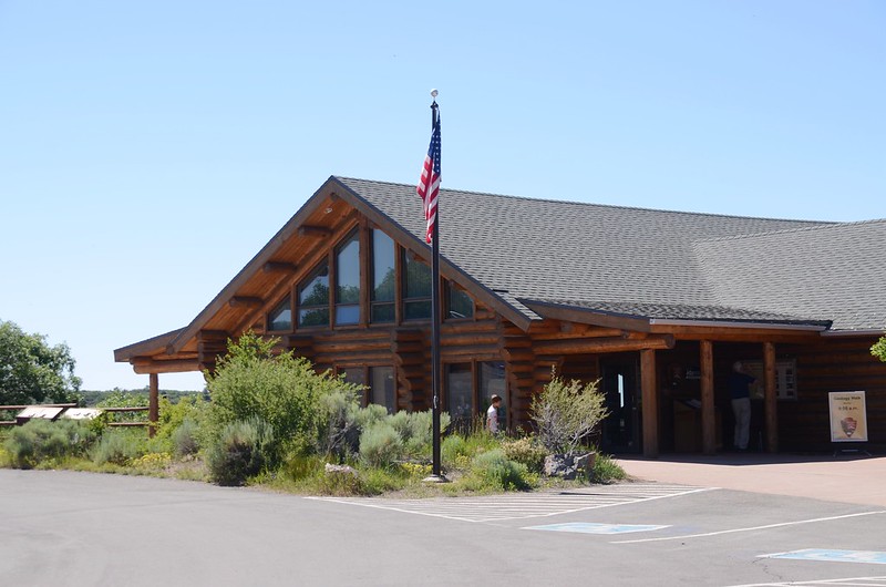
Black Canyon National Park Visitor Center
Black Canyon National Park Visitor Center
North Rim
北緣景觀區位在Crawford 南邊11 哩處,必須繞道 CO- 92經由Crawford State Park東邊石子路進入。北緣(The North Rim)景觀道路有六個觀景點,這邊的觀景點幾乎皆成垂直懸崖峭壁,景觀特殊,遊一趟北緣景觀道路大約也要花個2~3小時 。北緣景觀區冬季是封閉不開放的。
公園內南北兩緣間並沒有橋樑相通,要從南緣到北緣必須花兩三小時的車程繞道行駛。
East Portal
經由 East Portal Road可下抵峽谷底的Gunnison River 河邊,進而進入Curecanti National Recreation Area去露營、野餐和釣魚。East Portal Road幾乎是坡度達16%的髮夾彎,車輛長度有嚴格限制,由於道路非常陡峭,非性能良好四傳車難以進入;此路冬天是封閉的。
------------------------------------------------------------------------------------------------------
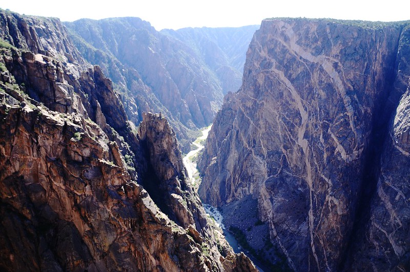
Black Canyon國家公園內整個峽谷東西綿延14哩長,最深處約800公尺,兩岸相隔最寬處約2公里(1.2哩)左右,最窄處僅約40呎寬,比起大峽谷的2~3000公尺深,17公里寬遜色許多,但是它的壯觀就在它的窄,峽谷壁近乎垂直,顯得谷底的Gunnison River 格外湍急。
Gunnison River通過Gunnison 黑峽谷國家公園每哩落差95呎,比起科羅拉多河通過大峽谷(Grand Canyon)國家公園每哩落差僅7.5呎顯然是陡峻湍急得多了;在Gunnison 黑峽谷國家公園上游未興建3個水壩(Blue Mesa Reservoir、Morrow Point Dam、Crystal Dam)前Gunnison River的衝擊力大約五倍於今日。
Black Canyon of the Gunnison國家公園裡獨特和壯觀的峽谷景觀是那些堅硬的原生代水晶岩經由大自然的水和岩石流動慢慢侵蝕而成,在北美洲再也找不到像此峽谷呈現如此狹窄、陡峭和令人吃驚的深度兼具的峽谷。
-------------------------------------------------------------------------------------------------
南緣(South Rim)景觀道路觀景點(由東向西):
Tomichi Point
此觀景點沿著崖邊有步道通往下個觀景點--Gunnison Point,步程約10分鐘。

Black Canyon, taken from Tomichi Point

Black Canyon, taken from Tomichi Point
Black Canyon, taken from Tomichi Point
Black Canyon, taken from Tomichi Point
Gunnison Point
此觀景點就在遊客中心後面崖邊,有石階步道抵達。

Gunnison Point , Black Canyon


Black Canyon, taken from Gunnison Point


Black Canyon, taken from Gunnison Point

Looking down into Gunnison River from Gunnison Point

Black Canyon National Park Visitor Center , Taken from Gunnison Point
Gunnison Point , Black Canyon
Black Canyon, taken from Gunnison Point
Black Canyon, taken from Gunnison Point
Looking down into Gunnison River from Gunnison Point
Black Canyon National Park Visitor Center , Taken from Gunnison Point
Pulpit Rock Overlook
觀景點距停車處約134碼(123公尺)。

Pulpit Rock Overlook , Black Canyon

Looking down into Gunnison River from Pulpit Rock Overlook


Black Canyon, taken from Pulpit Rock Overlook
Pulpit Rock Overlook , Black Canyon
Looking down into Gunnison River from Pulpit Rock Overlook
Black Canyon, taken from Pulpit Rock Overlook
Cross Fissures View
觀景點距停車處約357碼(326公尺)。

Black Canyon, taken from Cross Fissures View Trail

Black Canyon, taken from Cross Fissures View


Black Canyon, taken from Cross Fissures View


Black Canyon, taken from Cross Fissures View
Black Canyon, taken from Cross Fissures View Trail
Black Canyon, taken from Cross Fissures View
Black Canyon, taken from Cross Fissures View
Black Canyon, taken from Cross Fissures View
Rock Point
觀景點距停車處約294碼(269公尺)。

Black Canyon, taken from Rock Point

Black Canyon, taken from Rock Point

Black Canyon, taken from Rock Point
Black Canyon, taken from Rock Point
Black Canyon, taken from Rock Point
Black Canyon, taken from Rock Point
Devils Lookout
觀景點距停車處約607碼(555公尺)。

Black Canyon, taken from Devils Overlook
Black Canyon, taken from Devils Overlook
Chasm View
你有沒有覺得在此處不易看到谷底?黑峽谷的陡峭岩壁深度從Warner Point北岸的2700呎到“The Narrows”的1750呎,“The Narrows”介於Pulpit Rock和Chasm View兩處觀景點之間,是整個峽谷最淺和最窄的一段,在這裡兩岸距離不超過於1/4哩。


Black Canyon, Chasm View lookout point


Black Canyon, taken from Chasm View
Black Canyon, Chasm View lookout point
Black Canyon, taken from Chasm View
Gunnison River是一條落差極大的河流,在黑峽谷國家公園這一段平均每哩下降95呎,這急促的下降使得湍急的河水將峽谷切割得如此的深。

Black Canyon, taken from Chasm View

Benchmark on the Chasm View lookout, Black Canyon
Black Canyon, taken from Chasm View
Benchmark on the Chasm View lookout, Black Canyon
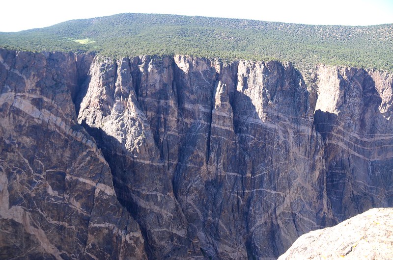
Painted Wall
觀景點距停車處約200碼(183公尺)。
公園內The Painted Wall從崖頂到河谷有2250呎(685公尺)深,是科羅拉多最高的峭壁,遠比紐約的帝國大廈(Empire State Building)高出1000呎(304公尺)。
岩壁上有好幾條明顯的淺色條紋大約是在一億年前形成,當時融化的岩漿被擠壓進這整片岩石的裂縫裡,冷卻變硬之後與原來的岩石融為一體,因為質地不同而形成這些花紋。


Black Canyon, taken from Painted Wall View


Black Canyon, taken from Painted Wall View
Black Canyon, taken from Painted Wall View
Black Canyon, taken from Painted Wall View
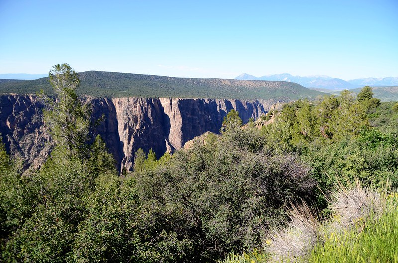
Cedar Point Nature Trail
本觀景點有一條Nature Trail ,步道長:單程303碼(277公尺)。
這是一條非常好的自然步道,步道沿途對各種植物立有詳細的自然解說牌。

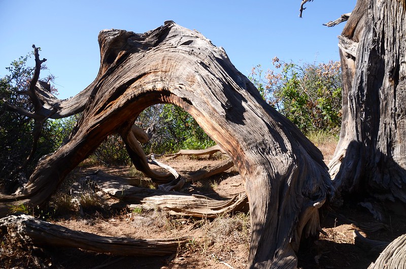
Utah juniper , taken from Cedar Point Trail

West Elk Mountain from Cedar Point, Black Canyon
在步道末端有兩個觀景點可俯瞰2000呎下的河谷,同時可看到著名的Painted Wall,這個科羅拉多最高的峭壁(2250呎)如同一個岩石島嶼般從深不見底的峽谷中突立而出。


Black Canyon, taken from Cedar Point

Black Canyon, taken from Cedar Point
Utah juniper , taken from Cedar Point Trail
West Elk Mountain from Cedar Point, Black Canyon
在步道末端有兩個觀景點可俯瞰2000呎下的河谷,同時可看到著名的Painted Wall,這個科羅拉多最高的峭壁(2250呎)如同一個岩石島嶼般從深不見底的峽谷中突立而出。
Black Canyon, taken from Cedar Point
Black Canyon, taken from Cedar Point
Dragon Point
觀景點距停車處約100碼(91公尺)。


Black Canyon, taken from Dragon Point
Black Canyon, taken from Dragon Point
Sunset View


Black Canyon, taken from Sunset View
Black Canyon, taken from Sunset View
High Point
此點是南緣景觀道路最西點,本觀景點並無良好展望;
Black Canyon, taken from High Point
但由此點有一條步道續往西行可抵公園最西端的一觀景點-- Warner Point,Warner Point Trail步道全長單程1373碼(0.78哩),坡度稍有起伏,但難度不高;步道一路穿梭於Juniper(杜松)林中逶迤而行,途中可西眺Montrose附近的沙丘地形,步道終點為Warner Point,頗有展望;全程來回約50分鐘。
Black Canyon, taken from High Point
但由此點有一條步道續往西行可抵公園最西端的一觀景點-- Warner Point,Warner Point Trail步道全長單程1373碼(0.78哩),坡度稍有起伏,但難度不高;步道一路穿梭於Juniper(杜松)林中逶迤而行,途中可西眺Montrose附近的沙丘地形,步道終點為Warner Point,頗有展望;全程來回約50分鐘。
該步道2011年已走過,今天家人有點累且時間也太晚,不想太晚到旅館所以就放棄了。
總計在南緣(South Rim)舊地重遊、走馬看花一趟停留時間約2小時30分鐘,我們於下午六點鐘左右離開公園前往今晚的住宿地~Delta的Riverwood Inn,抵達旅館已近晚上七點,明天就近參觀北緣(North Rim)。
沒有留言:
張貼留言