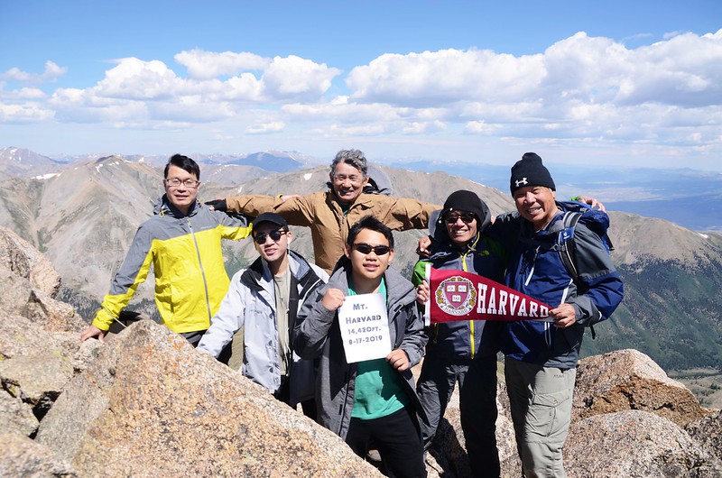
Taken from the summit of Mount Harvard
山岳簡介:
在科羅拉多州的14ers 中有好幾座是以美國東岸長春藤名校(Ivy League)命名,稱之為"Collegiate Peaks";包括Mount Harvard、Mount Princeton、Mount Oxford、Mount Columbia和Mount Yale。
Mount Harvard和Mount Yale都是由哈佛大學地質學教授J. D. Whitney在1869年命名,那年他帶領著哈佛大學地質探測隊到科羅拉多洛磯山脈探測,當他們隊伍經過Trout Creek Pass時,他們將看到的這座最高的山峰以自己的學校命名為Mount Harvard( 14,420 ft.),而將另一座較矮的山以Josiah Whitney的母校命名為Mount Yale( 14,196 ft.)。
Mount Harvard海拔14,420呎(4,395公尺),是科羅拉多第三高峰,也是美國本土48州第四高峰;科羅拉多高山中僅有三座超過14,400呎,Mount Harvard是其中的一座,其他兩座是Mount Elbert(14,433呎)和Mount Massive(14,421呎)。他位在Buena Vista小鎮西北方11哩處,一般登山客喜歡將此山和其南邊的另一座以哥倫比亞大學命名的14ers---Mount Columbia一起攀爬,因為兩山之間有一條長約2.2哩的山脊稜線相連,雖然是蠻累的行程,但一天爬兩座14ers也是值得的。
Mount Harvard和Mount Columbia兩座14ers我在2009年便和山友去攀登過,當年走了16個多小時,有夠累;前幾天山友邀約攀登Mount Harvard,剛好兩個孫子有空,我順便帶兩個孫子前往攀登,相隔10年後終有機會再度登上此座科州第三高峰。
--------------------------------------------------------------------------------------------------------
攀登山岳:Mount Harvard,海拔14,420呎/4,395公尺,科羅拉多州第三高峰
登山口:North Cottonwood Trailhead(海拔9,900呎/3,018公尺)
登山里程:來回約14哩/22.4公里
總爬升高度:約4,600呎/1,402公尺
登山時間:11小時05分
同行山友:沈宇靈、李建才、王如友(Tony)、Matthew、Jacob
--------------------------------------------------------------------------------------------------------
行車資訊:
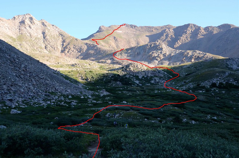
由Golden取道I-70州際道路西行,從I-70 W的 195 號出口下交流道沿CO-91 S往Copper Mountain/Leadville的方向行駛,CO-91 S行約22哩後在Leadville接US-24 南行,US-24 南行約35 哩抵Buena Vista遇Crossman Ave向右轉西行,Crossman Ave行0.3 哩後接著走Co Rd 350,1.8 哩後遇”T” 字路右轉接CR 361續行 (行不久轉為土石路) ,約1哩後左轉進入CR 365(土石路),再行約5哩後抵路終點即為登山口North Cottonwood Trailhead(海拔9,900呎);我們約在四點半左右抵達停車場,抵達時停車位已將停滿,可見此山之熱門程度。
行車路線圖:
步程簡述:
04:47 登山口上頭燈出發,海拔約9,900呎/3,018公尺。

North Cottonwood Trailhead
North Cottonwood Trailhead
05:00 過橫跨Cottonwood Creek的木橋,海拔約9,886呎/3,013公尺,距登山口約0.1哩;

The first footbridge across Cottonwood Creek
此後一路在Cottonwood Creek的南岸西行,步道大致寬敞緩升,走來舒爽。
The first footbridge across Cottonwood Creek
此後一路在Cottonwood Creek的南岸西行,步道大致寬敞緩升,走來舒爽。
05:12 進入Colegiate Peaks Wilderness範圍,路旁立有一根界牌,海拔約10,200呎/3,109公尺,距登山口約0.9哩。

Collegiate Peaks Wilderness sign
Collegiate Peaks Wilderness sign
05:35 抵另一座橫跨Cottonwood Creek的木橋,此處海拔10,330呎/3,149公尺,距登山口約1.5哩;

The second footbridge across Cottonwood Creek
過橋後步道轉為在Cottonwood Creek的北岸朝西北上山,路徑變陡且較為崎嶇不平。
The second footbridge across Cottonwood Creek
過橋後步道轉為在Cottonwood Creek的北岸朝西北上山,路徑變陡且較為崎嶇不平。
05:38 抵達Kroenke Lake和Horn Fork Basin岔路,此處海拔10,379呎/3,164公尺,距登山口約1.6哩;

Kroenke Lake & Horn Fork Basin trail junction
左岔往Kroenke Lake不取,取右岔往Horn Fork Basin and Bear Lake。
Kroenke Lake & Horn Fork Basin trail junction
左岔往Kroenke Lake不取,取右岔往Horn Fork Basin and Bear Lake。
06:17 過一小溪,海拔10,683呎/3,256公尺,距登山口約2.1哩;由小溪上墊腳石及原木過溪。
06:25 往Mount Columbia第一岔路,海拔10,930呎/3,331公尺,此處距登山口約2.6哩;此路線應該廢棄一段時間了,已看不出路跡,取直行續往Mount Harvard。
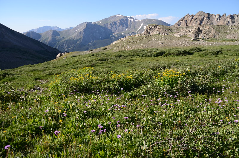
06:32 來到一空曠地,海拔約11,247呎/3,428公尺),此處距登山口約3.5哩;Mount Columbia西南稜矗立在右側(東邊),空地上野花遍開。

Morning light on the mountains

The meadow along the trail
Morning light on the mountains
The meadow along the trail
07:03 往Mount Columbia第二岔路,右往Mount Columbia,海拔11,489呎/3,502公尺,此處距登山口約3.7哩;取左往Mount Harvard。

Mount Harvard & Columbia trail junction
Mount Harvard & Columbia trail junction
07:05 出森林線,海拔約11,566呎/3,525公尺,此處距登山口約3.8哩。

Horn Fork Basin
在此地左側是Horn Fork Basin,Mount Harvard矗立在正前方北邊,遠眺南邊另一座14ers--Mount Yale( 14,196 ft / 4,327 m )正與Mount Harvard南北對峙。

Morning light on Mount Harvard, taken from Horn Fork Basin

Morning light on Mount Yale, taken from Horn Fork Basin
此後步道沿著Horn Fork Basin東側在矮Willows(不同於我們稱的柳樹)樹叢中穿梭前進。

Looking north at Harvard~Columbia ridge from Horn Fork Basin
Horn Fork Basin
在此地左側是Horn Fork Basin,Mount Harvard矗立在正前方北邊,遠眺南邊另一座14ers--Mount Yale( 14,196 ft / 4,327 m )正與Mount Harvard南北對峙。
Morning light on Mount Harvard, taken from Horn Fork Basin
Morning light on Mount Yale, taken from Horn Fork Basin
此後步道沿著Horn Fork Basin東側在矮Willows(不同於我們稱的柳樹)樹叢中穿梭前進。
Looking north at Harvard~Columbia ridge from Horn Fork Basin
07:28 越過Horn Fork Creek小溪和矮Willows樹叢後來到Horn Fork Basin的北端,步道開始往北邊Mount Harvard爬升,此處海拔約11,723呎/3,573公尺,距登山口約4.3哩;在此小休片刻再行。
07:40 步道沿著小溪Horn Fork Creek左岸上升,海拔約11,781呎/3,591公尺,距登山口約4.4哩,右下方是Horn Fork Creek。
07:45 抵達Horn Fork Basin北端高點,此時Mount Harvard整個山頭看得更清楚了。
Looking north at Mount Harvard from the top of Horn Fork Basin near 11,800 ft.
Looking north at Mount Harvard from the top of Horn Fork Basin near 11,800 ft.
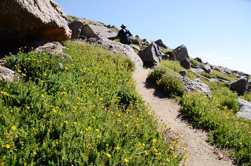
07:50 又過一小溪,海拔約11,913呎/3,631公尺,距登山口約4.6哩,過了小溪後步道開始往北爬升,坡度比前面陡多了,步道兩旁高山野花盛開。

Looking north at Mount Harvard from the trail between the top of Horn Fork Basin & Bear Lake junction


Mount Harvard Trail (the top of Horn Fork Basin to Bear Lake junction)
Looking north at Mount Harvard from the trail between the top of Horn Fork Basin & Bear Lake junction
Mount Harvard Trail (the top of Horn Fork Basin to Bear Lake junction)
08:21 抵達Bear Lake岔路,海拔12,363呎/3,768公尺,此處距登山口約5.2哩,左岔往Bear Lake,單程約0.3哩;

Bear Lake Trail junction
Looking south at Mount Yale from the trail between the top of Horn Fork Basin & Bear Lake junction
在此小休5分鐘後取右岔續往Mount Harvard爬升。

Taken from Bear Lake Trail junction

Mount Harvard Trail (Bear Lake junction to the flat shoulder)
Bear Lake Trail junction
Looking south at Mount Yale from the trail between the top of Horn Fork Basin & Bear Lake junction
在此小休5分鐘後取右岔續往Mount Harvard爬升。
Taken from Bear Lake Trail junction
Mount Harvard Trail (Bear Lake junction to the flat shoulder)
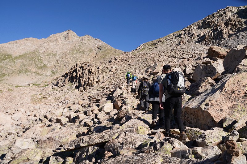
08:35 抵達13,598’ 峰東南側山腳下,接下來是一大片亂石坡往 13,598’ 峰東南側鞍部爬升,此處海拔12,638呎/3, 852公尺,距登山口約5.5哩。

The Talus Field located on the south side of the shoulder, which is on the east side of Unnamed Peak 13,598'

First views of Bear Lake

Mount Columbia from the trail near 12,638'
The Talus Field located on the south side of the shoulder, which is on the east side of Unnamed Peak 13,598'
First views of Bear Lake
Mount Columbia from the trail near 12,638'
08:37 上山途中Bear Lake浮現出其清澈碧綠的身影。
The Talus Field located on the south side of the shoulder, which is on the east side of Unnamed Peak 13,598'

Bear Lake from the trail near 13,000'
Mt. Columbia & Yale from the talus field on the south side of the shoulder
The Talus Field located on the south side of the shoulder, which is on the east side of Unnamed Peak 13,598'
Bear Lake from the trail near 13,000'
Mt. Columbia & Yale from the talus field on the south side of the shoulder
09:06 登抵13,598’ 峰東南邊鞍部,海拔13,009呎/3, 965公尺,距登山口約5.8哩,在此處清楚的看見Mount Harvard南面坡的全貌;

Mount Harvard Trail (the steep slope below Mt. Harvard's south ridge)

Taken from the shoulder on the east side of Unnamed Peak 13,598'

Mount Columbia from the shoulder on the east side of Unnamed Peak 13,598'
在此小休後續往山頂前進,先上到高點後緩下坡往一條小溪澗下行。


Mount Harvard from the shoulder on the east side of Unnamed Peak 13,598'
Mount Harvard Trail (the steep slope below Mt. Harvard's south ridge)
Taken from the shoulder on the east side of Unnamed Peak 13,598'
Mount Columbia from the shoulder on the east side of Unnamed Peak 13,598'
在此小休後續往山頂前進,先上到高點後緩下坡往一條小溪澗下行。
Mount Harvard from the shoulder on the east side of Unnamed Peak 13,598'
09:20 經過一條小溪澗,海拔13,026呎/3, 970公尺,距登山口約6.0哩;過小溪澗後路徑稍偏左行且坡度變陡,步道導向右上方一座小平台。
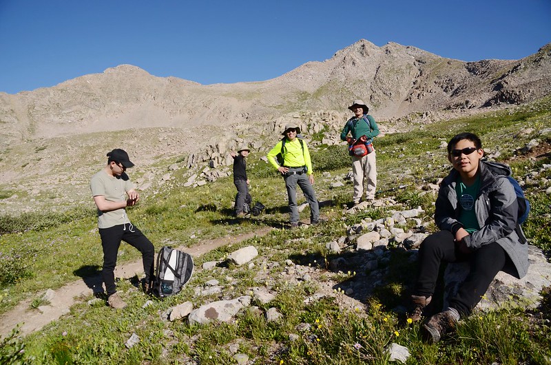
09:32 登上一小平台,平台左側山坡下一大片雪原,此處海拔13,192呎/4, 020公尺,距登山口約6.1哩;

Looking southeast at Harvard~Columbia ridge from the slope below Mt. Harvard's south ridge
我們在此小休,豆豆和貝貝有點累了,昨晚一晚沒睡,僅在車上小瞇一個多小時,坐下來沒一會兒就打起瞌睡來了!


The snowfield on the trail below Mt. Harvard's south ridge
Looking southeast at Harvard~Columbia ridge from the slope below Mt. Harvard's south ridge
我們在此小休,豆豆和貝貝有點累了,昨晚一晚沒睡,僅在車上小瞇一個多小時,坐下來沒一會兒就打起瞌睡來了!
The snowfield on the trail below Mt. Harvard's south ridge
09:40 繼續上山,登山步道自此開始到山頂才是真正挑戰的開始,一路在岩石坡上陡登,直線距離約3,000呎(約914公尺)的路程要爬升約1,300呎(近400公尺),而且一路幾乎是岩石坡或鬆散的礫石坡,有幾段還是近乎攀岩的危岩路段;先朝山頂左下方的稜線方向爬升,步道上到該稜線後再右切沿山腰腰繞登頂。


Mount Harvard Trail (the steep slope below Mt. Harvard's south ridge)
Mount Harvard Trail (the steep slope below Mt. Harvard's south ridge)
10:17 登上Mount Harvard南稜稜線(海拔約13,701呎/4,176公尺),距登山口約6.4哩;

Looking south at mountains from the slope below Mt. Harvard's south ridge near 13700'
此後即朝山頂在南坡腰繞往上攀升。


Mount Harvard Trail (the south ridge to the summit)


Mount Harvard Trail (the south ridge to the summit)
Looking south at mountains from the slope below Mt. Harvard's south ridge near 13700'
此後即朝山頂在南坡腰繞往上攀升。
Mount Harvard Trail (the south ridge to the summit)
Mount Harvard Trail (the south ridge to the summit)
11:17 登上Mount Harvard南稜山頂下稜線一缺口,從一岩石缺口清楚俯瞰西面盆地,及西北邊Huron Peak等14ers;


Taken from the ridge just below Mt. Harvard's summit
Looking south at Mount Columbia & Yale from Mt. Harvard Trail below the summit
過了岩石缺口後續往山頂爬升。

The final summit pitch, climb up through the rocks to reach the top
Taken from the ridge just below Mt. Harvard's summit
Looking south at Mount Columbia & Yale from Mt. Harvard Trail below the summit
過了岩石缺口後續往山頂爬升。
The final summit pitch, climb up through the rocks to reach the top
11:20 前面一片光滑岩壁,必須沿著光滑岩壁右側小小的溝縫手腳並用的爬升,勿左切上稜線,上了稜線會遇到更危險的攀登。
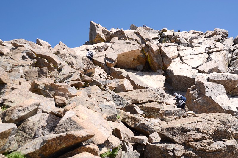


The final summit pitch, climb up through the rocks to reach the top
The final summit pitch, climb up through the rocks to reach the top
11:25 抵達山頂下最後一片落差極大的岩壁,小心上攀,一失足將成千古恨;

Yulin & Tony on the summit of Mt. Harvard


Climbing up to the summit of Mount Harvard
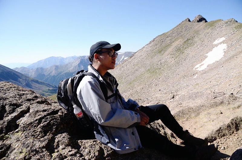
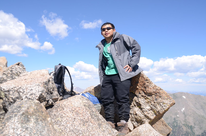
攀上此岩壁後即是Mount Harvard的山頂,繼2009首登此峰後再度登頂科羅拉多第三高峰Mount Harvard (14,420呎 / 4,395公尺),山友宇靈和Tony早在山頂等候多時,比我們早登頂將近一個小時;此山山頂狹小而且都是大巨石堆,不適合太多人聚集山頭,還好今天山頂登山客不多,可以悠閒地在此休息拍照。

Matthew & Jacob on the summit of Mount Harvard

Matthew、Jacob & me on the summit of Mount Harvard

Matthew on the summit of Mount Harvard
Jacob on the summit of Mount Harvard


Me on the summit of Mount Harvard
Yulin & Tony on the summit of Mt. Harvard
Climbing up to the summit of Mount Harvard
攀上此岩壁後即是Mount Harvard的山頂,繼2009首登此峰後再度登頂科羅拉多第三高峰Mount Harvard (14,420呎 / 4,395公尺),山友宇靈和Tony早在山頂等候多時,比我們早登頂將近一個小時;此山山頂狹小而且都是大巨石堆,不適合太多人聚集山頭,還好今天山頂登山客不多,可以悠閒地在此休息拍照。
Matthew & Jacob on the summit of Mount Harvard
Matthew、Jacob & me on the summit of Mount Harvard
Matthew on the summit of Mount Harvard
Jacob on the summit of Mount Harvard
Me on the summit of Mount Harvard
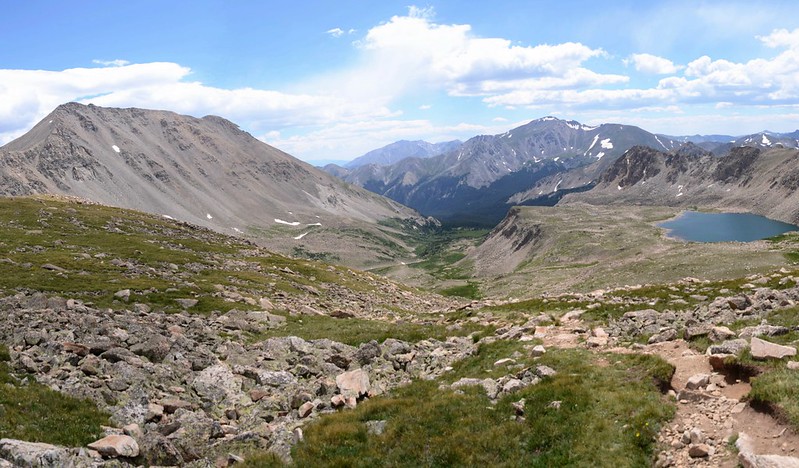
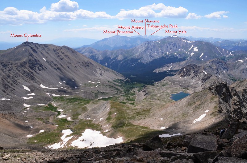
看別人紀錄大概都在4~5個小時左右登頂,而我卻花了六個多小時,體力真的差太多了!Mount Harvard山頂展望奇佳無比,數一數在Sawatch Range的14ers中,北邊有科州第一高峰Mount Elbert等7座、南邊有Mount Yale等6座皆盡收眼底,甚至連Mosquito Range和Front Range的幾座14ers也依稀可見。

Looking northwest at mountains from the summit of Mount Harvard

Looking south at mountains from Mount Harvard's summit

Looking southeast at Harvard--Columbia ridge from Mount Harvard

Looking down at Bear Lake from Mount Harvard's summit
Looking northwest at mountains from the summit of Mount Harvard
Looking south at mountains from Mount Harvard's summit
Looking southeast at Harvard--Columbia ridge from Mount Harvard
Looking down at Bear Lake from Mount Harvard's summit
12:00 在山頂休息用餐後下山,經過兩段危岩後一路沿著岩石坡下山。


Climbing down from Mount Harvard


Climbing down from Mount Harvard
Climbing down from Mount Harvard
Climbing down from Mount Harvard
13:07 下抵平台雪原處,續往13,598’ 峰東南邊鞍部前進下山。
13:44 回到Bear Lake岔路上頭Point 13,598’東南側山腳下岩石坡盡頭,接下來的步道就較為好走了。

Taken from the talus field on the south side of the shoulder (4)
Taken from the talus field on the south side of the shoulder (4)
13:51 途經Bear Lake岔路後續行下山。

Looking south at Mount Yale from the trail between the top of Horn Fork Basin & Bear Lake junction
Looking south at Mount Yale from the trail between the top of Horn Fork Basin & Bear Lake junction
14:14 抵達Horn Fork Basin頂端過小溪處,過溪後沿著Horn Fork Basin東側Willows叢間小徑下山。

Mount Harvard from Horn Fork Basin

Mount Yale from Horn Fork Basin
Mount Harvard from Horn Fork Basin
Mount Yale from Horn Fork Basin
14:29 離開Horn Fork Basin續行下山。
14:31 路過Mount Columbia岔路後下山。
15:25 抵達Kroenke Lake和Horn Fork Basin岔路,取左岔下山。
15:28 過橫跨Cottonwood Creek的木橋後沿著Cottonwood Creek的南岸下山。
16:04 返抵登山口停車場,其他山友已在車上等候,稍微整裝後搭宇靈的便車返回Golden,結束一天有點操的登山行程。
沒有留言:
張貼留言