
Mount Lincoln
美國將本土(48州)14,000呎(4,267公尺)以上的高山稱為Fourteeners (14ers),但是要正式列入14ers的排名有一個原則~~兩座以上相比鄰的山峰如果都高於14,000呎(4,267公尺),則兩山間之鞍部必須深於300呎( 91.4公尺)才都得以列入排名,否則較低的一座山就不列入;根據此一原則,科羅拉多州雖然有 58 座14,000呎以上的高山,但正式列入14ers排名的祇有53座,分佈在六個不同的山脈。這些高山使科羅拉多成為世界上登山者之天堂,跟台灣的登山客追求百岳一樣,這兒的登山客把爬完14ers視為一種驕傲。
在53座14ers中有三座距丹佛不遠,分布在Mosquito Range的14ers-- Mount Democrat、Mount Lincoln、 Mount Bross,這三座山由於是同屬一山塊,相距都不遠,如採“O”形連走全程約13.3公里,中途又經過一座未正式列入14ers的 Mount Cameron,則一天之內可同時爬完四座14,000呎( 4,267公尺 )以上的高山,真如老美所說的“A great deal !”這四座高山登山界稱之為“The Decalibron”,The Decalibron我已走過三趟,上週幾位山有約集攀登此山塊,所以有了四度攀登的機會。
上週六(21)早晨05:00我們在Morrison的Park n Ride會合後,搭乘阿才的車前往登山口。
-------------------------------------------------------------------------------------------------------
攀登山岳:
Mount Democrat:海拔14,148呎 / 4,312公尺
Mount Cameron:海拔14,238呎 / 4,340公尺
Mount Lincoln:海拔14,286呎 / 4,354公尺
Mount Bross:海拔14,172呎 / 4,320公尺
登山里程:8.27哩/13.3公里
總爬高度:3,793呎/1,156公尺
登山時間:11小時14分
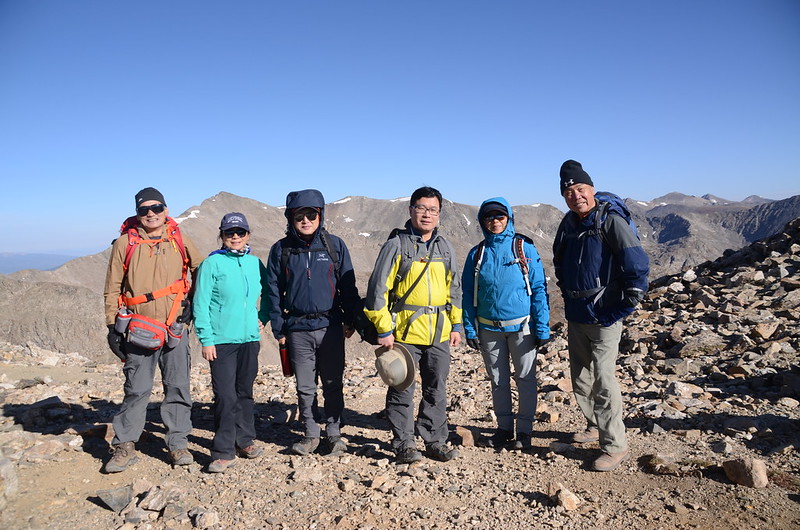
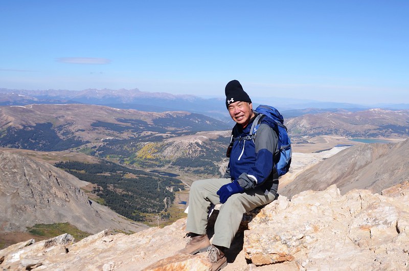
登山人員:Tony、阿才、姜官祥、王冰、趙薇、陳基滿-------------------------------------------------------------------------------------------------------
行車資訊:
由Morrison的Park n Ride上CO 470南行轉US 285往Fairplay西南行,US 285行約67.2哩抵Fairplay後右轉CO 9公路往Alma西北行,行約6.0哩抵Alma於County Road 8 (Buckskin St)向左轉,一路沿County Road 8行約5.5哩於06:45 抵達Kite Lake Trailhead停車場(每部車停車費美金3元)。
步程簡述:
07:05 登山口出發,海拔11,972呎/3,649公尺;

Kite Lake Trailhead
從登山口越過Kite lake的出水口,穿越露營區後便開始沿之字形小徑上坡;
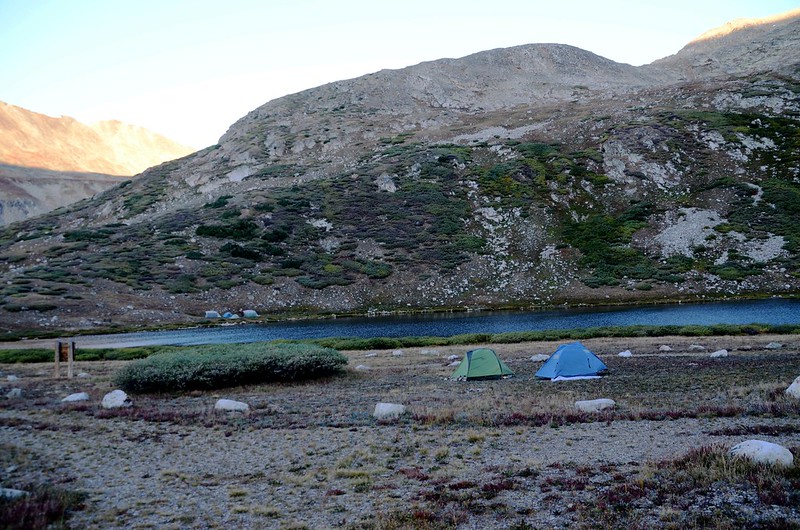
Kite Lake & camping site
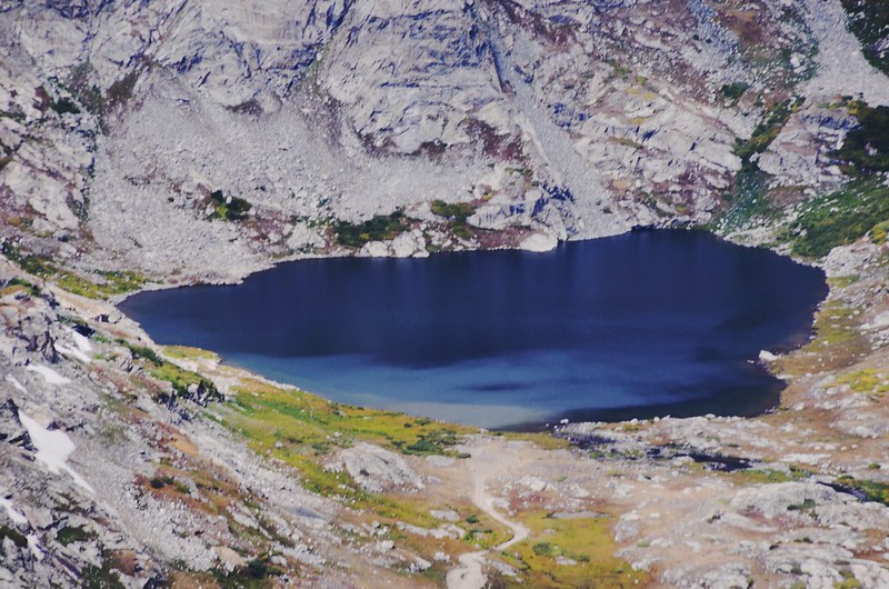
此時回頭往下看,Kite lake菱形的湖面,蜿蜒的車道,正如一幅大風箏躺在大地上,難怪稱之為Kite lake。


Looking down at Kite Lake from the way up to Mount Democrat
Kite Lake Trailhead
從登山口越過Kite lake的出水口,穿越露營區後便開始沿之字形小徑上坡;
Kite Lake & camping site
此時回頭往下看,Kite lake菱形的湖面,蜿蜒的車道,正如一幅大風箏躺在大地上,難怪稱之為Kite lake。
Looking down at Kite Lake from the way up to Mount Democrat
07:38 步道旁一類似礦區遺址,海拔12,408呎/3,782公尺,距登山口約0.62哩/1.0公里。

Passing the Kentucky Belle Mine near 12,408 ft.
Passing the Kentucky Belle Mine near 12,408 ft.
07:48 抵達草地頂端小平台,海拔12,562呎/3,829公尺,距登山口約0.81哩/1.3公里;

On the way up to Mount Democrat
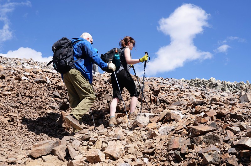
接下來是岩石坡,沿著岩石坡明顯小徑上行。
On the way up to Mount Democrat
On the way up to Mount Democrat
接下來是岩石坡,沿著岩石坡明顯小徑上行。
On the way up to Mount Democrat
08:07 抵達鞍部下一小平台地,海拔12,753呎/3,887公尺,距登山口約1.0哩/1.6公里;仰望通往鞍部的岩石坡是一路”之”字形往上盤升,看似短短的一段路,走來還不輕鬆。


On the way up to Mount Democrat

On the way up to Mount Democrat
On the way up to Mount Democrat
On the way up to Mount Democrat
09:15 登上Mount Democrat 和 Mount Cameron 間的鞍部,海拔13,386呎/4,080公尺,距登山口約1.62哩/2.6公里;

The saddle between Democrat & Cameron

Taken at the Mount Democrat - Cameron saddle

Looking north at mountains from Mount Democrat-Cameron saddle
鞍部邊有一個礦坑遺址,類似此遺址此地區到處都是,因為這地區有好多廢棄的礦區,也因為如此,事實上此四座山的地主一度不同意開放此山區,因為地主怕登山客誤入危險礦區,導致廢棄坑道崩陷而發生意外,後經14ers有關單位與地主溝通後才同意開放部分路段供登山客通行。

Old mine building at the saddle between Democrat & Cameron
The saddle between Democrat & Cameron
Taken at the Mount Democrat - Cameron saddle
Looking north at mountains from Mount Democrat-Cameron saddle
鞍部邊有一個礦坑遺址,類似此遺址此地區到處都是,因為這地區有好多廢棄的礦區,也因為如此,事實上此四座山的地主一度不同意開放此山區,因為地主怕登山客誤入危險礦區,導致廢棄坑道崩陷而發生意外,後經14ers有關單位與地主溝通後才同意開放部分路段供登山客通行。
Old mine building at the saddle between Democrat & Cameron
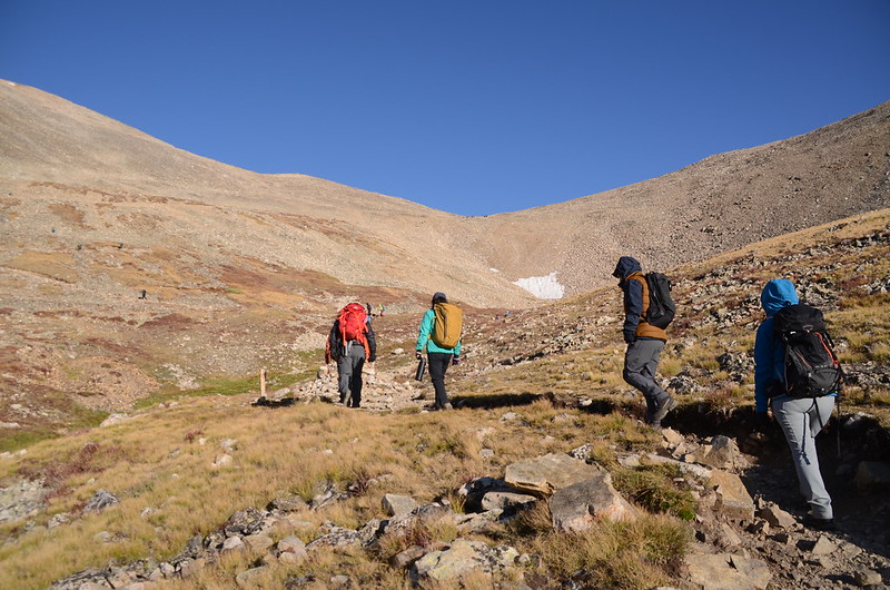
小休後沿Mount Democrat東北稜的南坡面爬升。
09:28 步道轉到Mount Democrat東北稜稜線上岩石坡沿稜爬升,海拔13,514呎/4,119公尺,距登山口約1.8哩/2.9公里。
09:34 步道脫離稜線左切回Mount Democrat東北稜的南坡面爬升,海拔13,583呎/4,140公尺;
On the way up to Mount Democrat
此後路段陡峭又易滑動,上山還好,下山可得小心了!

On the way up to Mount Democrat

Looking northeast at mountains from Mount Democrat's southeast ridge
On the way up to Mount Democrat
此後路段陡峭又易滑動,上山還好,下山可得小心了!
On the way up to Mount Democrat
Looking northeast at mountains from Mount Democrat's southeast ridge
10:18 登上Mount Democrat東南方假山頭,海拔13,947呎/4,251公尺,距登山口約2.1哩/3.4公里,Democrat真正山頂在西邊不遠處,在此望去山頂上登山客還不少;

Looking northwest at Democrat's summit from It's false summit

Looking southwest at mountains from Mount Democrat false summit
左側稜尾有一處Kite Lake展望點,下山再前往,先取西往Mount Democrat山頂前進。

Looking east at Mountains from Mount Democrat's southeast ridge near the summit

Looking northeast at mountains from Mount Democrat's southeast ridge near the summit
Looking northwest at Democrat's summit from It's false summit
Looking southwest at mountains from Mount Democrat false summit
左側稜尾有一處Kite Lake展望點,下山再前往,先取西往Mount Democrat山頂前進。
Looking east at Mountains from Mount Democrat's southeast ridge near the summit
Looking northeast at mountains from Mount Democrat's southeast ridge near the summit
10:43 登頂Mount Democrat,海拔14,148呎 / 4,312公尺(GPS顯示14,140呎 / 4,310公尺),距登山口約2.36哩/3.8公里;

Taken at Mount Democrat's summit
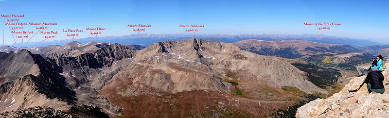
山頂展望奇佳,四邊遠眺計有近二十座14ers盡收眼底。
Looking west at Mountain from Mount Democrat's summit

Looking north at mountains from Mount Democrat's summit

Looking down CO 91 Hwy from Mount Democrat's summit

Mountains view from Mount Democrat's summit
Taken at Mount Democrat's summit
山頂展望奇佳,四邊遠眺計有近二十座14ers盡收眼底。
Looking west at Mountain from Mount Democrat's summit
Looking north at mountains from Mount Democrat's summit
Looking down CO 91 Hwy from Mount Democrat's summit
Mountains view from Mount Democrat's summit
我們在山頂拍照休息後循原路下山。
11:08 返抵Mount Democrat東南方假山頭,先取東南行到稜尾展望點俯瞰Kite Lake。
11:10 抵達Kite Lake viewpoint,海拔13,953呎 / 4,253公尺,在此是俯瞰Kite Lake最佳位置;
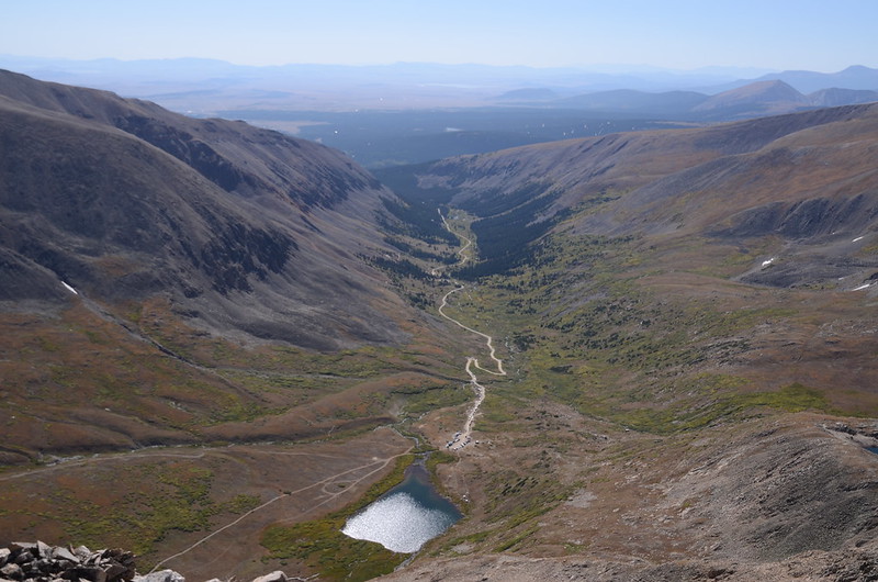

Looking down at Kite Lake from Kite Lake viewpoint

Taken at the Kite Lake viewpoint (Mount Democrat false summit)
小休一下後回到假山頭岔路取右下山,下山路段陡峭又易滑動,小心下行。
Looking down at Kite Lake from Kite Lake viewpoint
Taken at the Kite Lake viewpoint (Mount Democrat false summit)
小休一下後回到假山頭岔路取右下山,下山路段陡峭又易滑動,小心下行。
11:49 下抵Mount Democrat 和 Mount Cameron 間的鞍部,在此休息午餐。
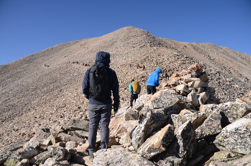
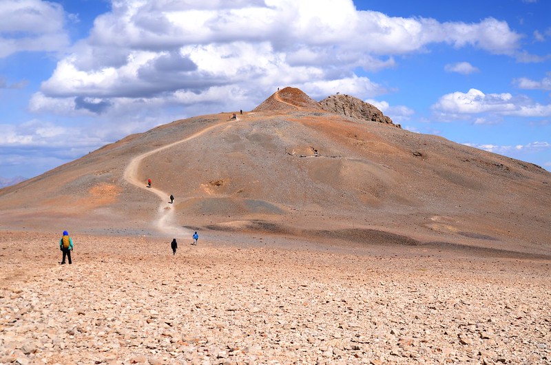
12:18 續行,沿Mount Cameron西南稜南面坡上行。

Looking southwest at Mount Democrat from Mount Cameron's southwest ridge


Looking down at Kite Lake from Mount Cameron's southwest ridge
Looking southwest at Mount Democrat from Mount Cameron's southwest ridge
Looking down at Kite Lake from Mount Cameron's southwest ridge
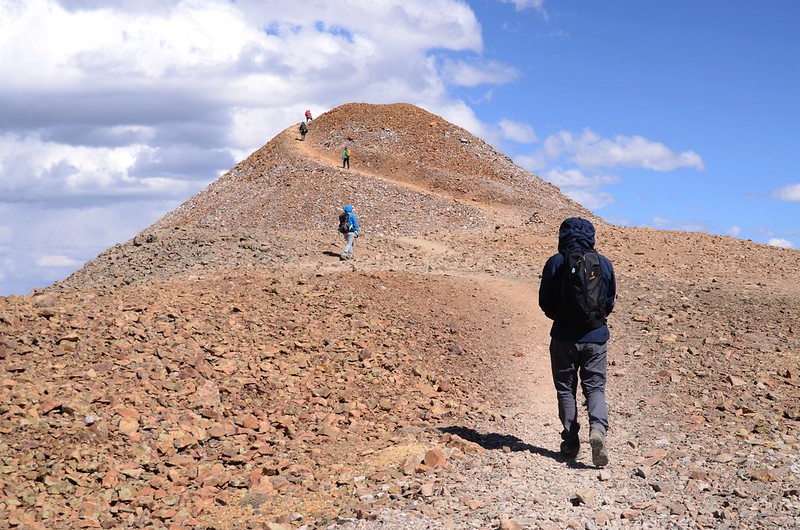
13:03 登上Mount Cameron西南稜稜線,海拔13,625呎 / 4,153公尺,距登山口約3.73哩/6.0公里;此後沿西南稜稜線上行。
On the way up to Mount Cameron
On the way up to Mount Cameron
13:21 抵達Mount Cameron山頂稜線西南端下一稜線缺口,海拔13,871呎 / 4,228公尺,再行40公尺登上Mount Cameron西南稜稜線行一段路後及取左在Mount Cameron山頂稜線下北面坡腰繞往山頂東北行。

On the way up to Mount Cameron

On the way up to Mount Cameron
Looking down Wheeler Lake from Mount Cameron's southwest ridge
On the way up to Mount Cameron
On the way up to Mount Cameron
Looking down Wheeler Lake from Mount Cameron's southwest ridge
13:53 登頂Mount Cameron,海拔14,238呎 / 4,340公尺(GPS顯示14,196呎 / 4,327公尺),距登山口約4.29哩/6.9公里;


Taken at Mount Cameron's summit
Mount Cameron山頂是一寬平的廣場,還真看不出是一處山頂,此山海拔雖超過14,000呎,但因與Mount Lincoln間的鞍部未超過300呎所以未名列正式的14ers名單中;在山頂拍照後續朝東北往Mount Lincoln前進。

On the way up to Mount Lincoln
Taken at Mount Cameron's summit
Mount Cameron山頂是一寬平的廣場,還真看不出是一處山頂,此山海拔雖超過14,000呎,但因與Mount Lincoln間的鞍部未超過300呎所以未名列正式的14ers名單中;在山頂拍照後續朝東北往Mount Lincoln前進。
On the way up to Mount Lincoln
14:10 下抵Mount Cameron、Mount Lincoln間鞍部岔路,海拔14,065呎 / 4,287公尺,距登山口約4.54哩/7.3公里;右岔腰繞Mount Cameron東側山腰往Mount Bross,直行往Mount Lincoln,取直行先攀登Mount Lincoln。
On the way up to Mount Lincoln
On the way up to Mount Lincoln
14:25 登上Mount Lincoln前山頭,海拔14,220呎 / 4,334公尺,距登山口約4.72哩/7.6公里;

On the way up to Mount Lincoln
續往東北方Mount Lincoln前行。
On the way up to Mount Lincoln
續往東北方Mount Lincoln前行。
14:35 登頂Mount Lincoln,海拔14,286呎 / 4,354公尺(GPS顯示14,282呎 / 4,353公尺),距登山口約4.9哩/7.9公里;


Taken at Mount Lincoln's summit
Mount Lincoln山頂有兩個Benchmark銅標,山頂展望很好,拍照休息後續循原路下山前往Mount Bross。


Mount Lincoln's summit benchmark

Taken at Mount Lincoln's summit
Taken at Mount Lincoln's summit
Mount Lincoln山頂有兩個Benchmark銅標,山頂展望很好,拍照休息後續循原路下山前往Mount Bross。
Mount Lincoln's summit benchmark
Taken at Mount Lincoln's summit
15:04 回到Mount Cameron與Mount Lincoln間鞍部Mount Bross岔路,取左岔腰繞Mount Cameron東側山腰往Mount Bross南行。
15:22 抵達Mount Cameron與Mount Bross 間鞍部最低鞍,海拔13,881呎 / 4,231公尺,距登山口約5.78哩/9.3公里。
15:35 抵一處岔路,右岔為登山步道,左直行為Jeep車道,取左沿車道上Mount Bross山頂。
15:56 登頂Mount Bross,海拔14,172呎 / 4,320公尺,距登山口約6.46哩/10.4公里;
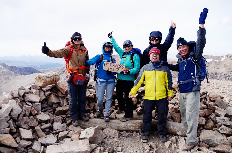

Taken at Mount Bross' summit
山頂風大,拍照後快速下山。

Looking northwest at Mount Democrat、Cameron & Lincoln from Mount Bross
Taken at Mount Bross' summit
山頂風大,拍照後快速下山。
Looking northwest at Mount Democrat、Cameron & Lincoln from Mount Bross
16:07 下山,由山頂南行十幾公尺隨即右下切,步道在Mount Bross的西面坡朝西南下行,坡陡、細石礫路面很滑,小心下行,很容易滑倒。

On the way down from Mount Bross
On the way down from Mount Bross
16:18 下抵一岔路,右岔係15:35所遇岔路來接,取左岔下山,海拔13,986呎 / 4,263公尺,距登山口約6.65哩/10.7公里;路況如同前半段,陡峭、易滑,行來特別小心。

On the way down from Mount Bross
On the way down from Mount Bross
16:41 步道切到Mount Bross西南稜稜線,海拔13,589呎 / 4,142公尺,距登山口約7.02哩/11.3公里;

On the way down from Mount Bross
右轉沿稜線下行,稜線很窄,曝露感十足,小心下行。
On the way down from Mount Bross
右轉沿稜線下行,稜線很窄,曝露感十足,小心下行。
16:45 左側一岔路痕跡,海拔13,517呎 / 4,120公尺,岔路很陡,岔路口以石頭擋住,取直沿Mount Bross西南稜下行。
16:53 又抵一處左岔路,海拔13,389呎 / 4,081公尺,距登山口約7.08哩/11.4公里;前面一群山友和Tony皆取直線沿Mount Bross西南稜下行,但根據記錄稜線危險難走,Alltrails的航跡大部分取左切下凹谷,再沿左側另一支稜的北側山腰下山,我前三次登此山也都走該路線,為顧及山友安全我決定取左切走較有把握的路線。
17:05 下抵谷地,海拔13,215呎 / 4,028公尺,在此轉到另一支稜的北側山腰朝西南下行。
17:51 右切捷徑,海拔12,487呎 / 3,806公尺,距登山口約7.7哩/12.4公里。
18:04 接回正確步道取右下行。
18:15 返抵登山口,全員到齊後開車返回丹佛。