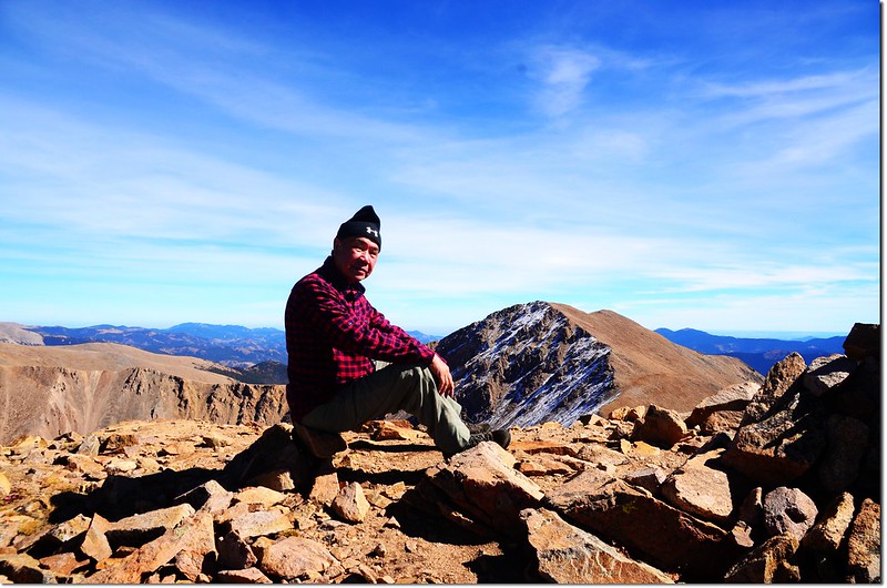
On the summit of Mount Parnassus, in the background is Bard Peak
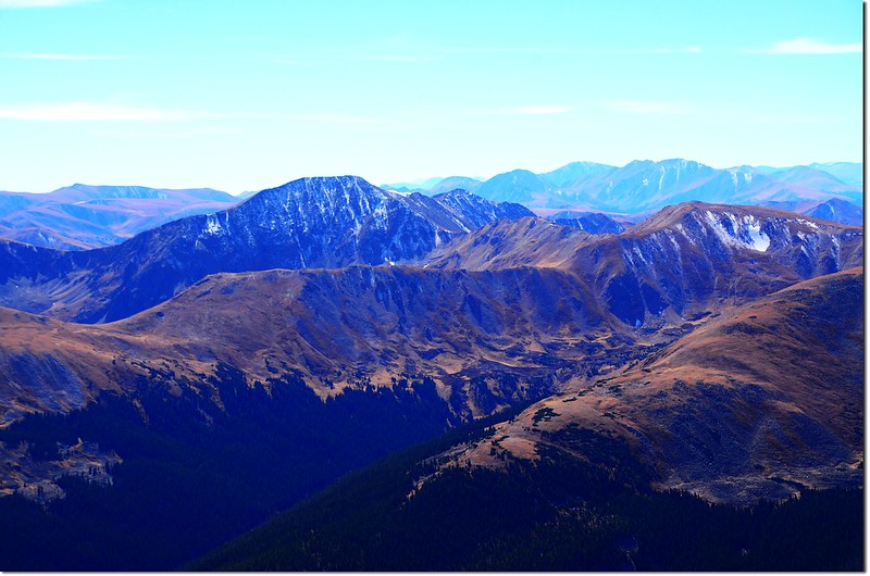
Looking north onto Rockies from Grays Peak summit
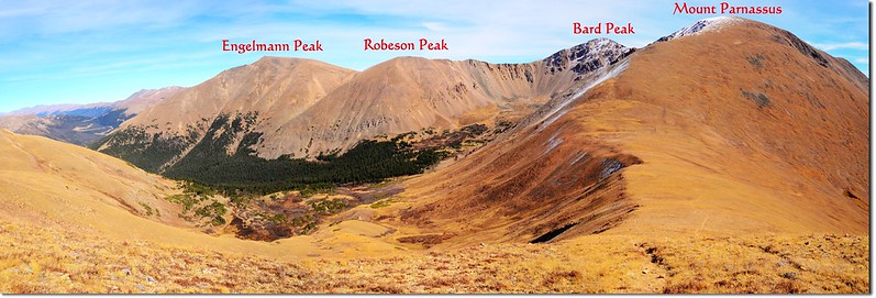
Mount Parnassus和Woods Mountain同是丹佛附近隸屬落磯山脈Front Range的兩座比鄰的高山,Mount Parnassus海拔13,574 呎(4,137公尺),是科羅拉多排名第208高的高山,Woods Mountain海拔12,940 呎(3,944公尺),兩山相隔1.2哩,中間隔著一個落差1,075呎(328公尺)的鞍部(以Mount Parnassus山頂計算),一般登山客喜歡將這兩座山一次連登,或是辛苦一點再登Mount Parnassus東邊直線距離約一哩的另一座13ers~Bard Peak;此次我僅攀登Mount Parnassus和Woods Mountain兩座,至於Bard Peak就另外再安排時間來攀登了。
---------------------------------------------------------------------------------------------------------
行車資訊:
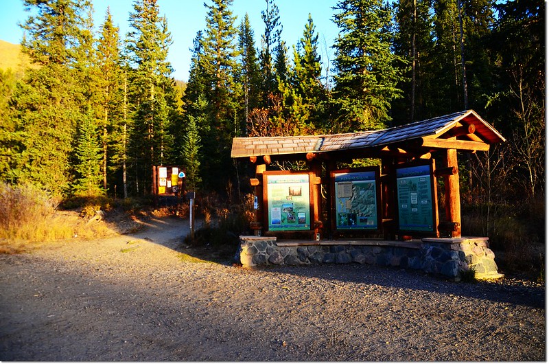
由丹佛沿I-70州際公路西行,然後在Exit 218出口下交流道,隨即右後轉彎行駛一條兩三百呎的石子路即抵達Herman Gulch Trailhead,登山口有一處蠻大的停車場,登山口就在停車場的北邊中間位置,此登山口是Herman Gulch Trail和Watrous Gulch Trail共用登山口。
攀登山岳:
Mount Parnassus:海拔13,574 呎(4,137公尺)
Woods Mountain:海拔12,940 呎(3,944公尺)
登山口:Herman Gulch Trailhead(海拔10,300呎/3,139公尺)
總爬升高度:約4,500呎(1,372公尺 )
登山里程:約10哩(16公里 )
登山時間:8小時30分
★以上紀錄均含走錯路的里程(約2哩)、爬升高度(約600呎)、時間(50分)
Mount Parnassus:海拔13,574 呎(4,137公尺)
Woods Mountain:海拔12,940 呎(3,944公尺)
登山口:Herman Gulch Trailhead(海拔10,300呎/3,139公尺)
總爬升高度:約4,500呎(
登山里程:約10哩(
登山時間:8小時30分
★以上紀錄均含走錯路的里程(約2哩)、爬升高度(約600呎)、時間(50分)
---------------------------------------------------------------------------------------------------------
步程簡述:
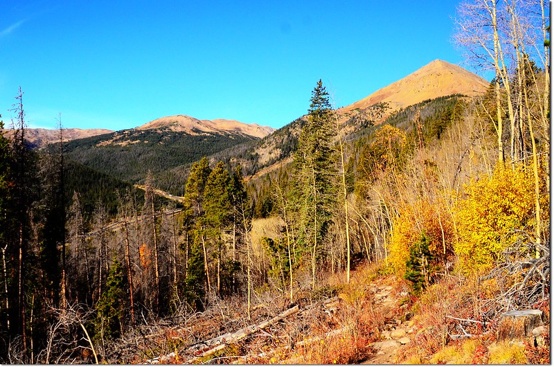
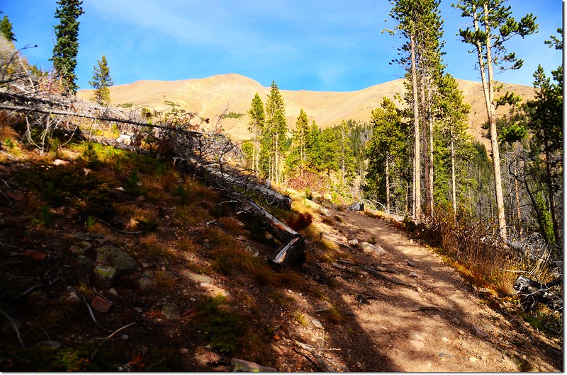
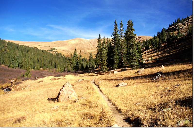
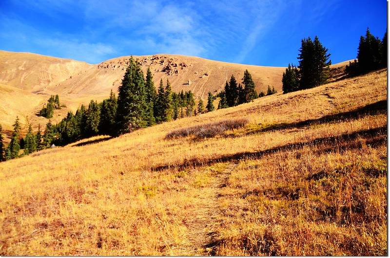
07:34 由登山口出發,Watrous Gulch Trail在Mount Machebeuf 的東南側坡往東前進,一開始數百呎的步道在松林中平緩前進,步道維護得很好。
Herman Gulch Trailhead
07:40 遇到岔路,左岔步道為Herman Gulch Trail,是通往Herman Lake的步道,右直行才是Watrous Gulch Trail往Mount Parnassus的正確步道,此處距登山口約400呎(122公尺),路牌標示已不見,我又因準備工作未紮實,取左走了約一哩多才驚覺有誤,再回頭已延誤了一個小時,多走了兩哩多,爬升約600呎,就當作熱身運動吧!
08:30 回到岔路口左轉,回到正確路線在山腰緩升東行,兩側Aspen葉子大多已掉光。
Looking down onto I-70 from Watrous Gulch Trail
Parnassus ridge taken during a hike on Parnassus
Parnassus ridge taken during a hike on Parnassus
09:25 遇到小溪Watrous Gulch Creek,跨過橫在小溪上的木板到東岸,右邊不遠處森林中有一座傾頹的木屋或shelter遺址;
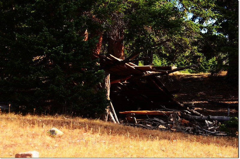
Fall-Out Shelter
步道立即分成兩條,右往東續行為Bard Creek Trail (#83),左往北行是Watrous Gulch Trail(#95),取左北行沿Watrous Gulch前進;此地海拔約11,160呎(3,402公尺),距登山口約1.5哩(2.4公里)。
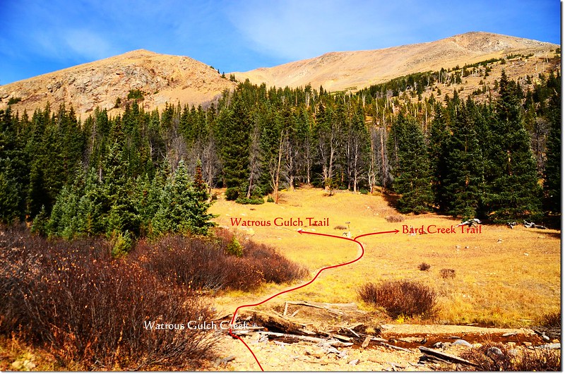
Watrous Gulch Trail & Bard Creek Trail junction
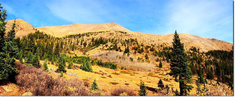
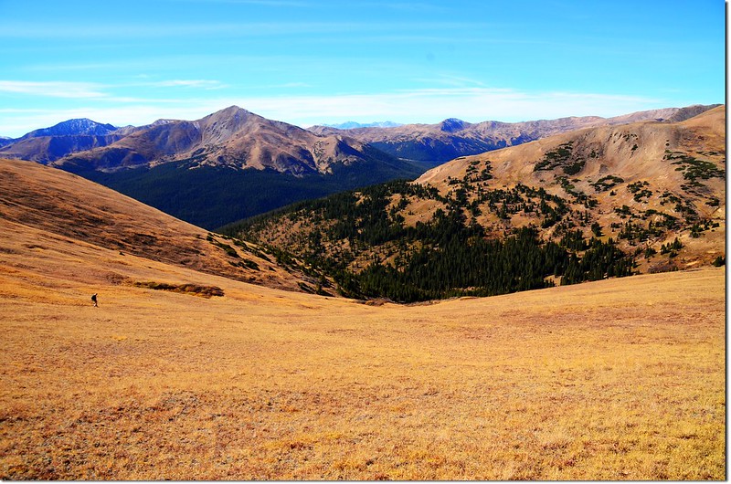
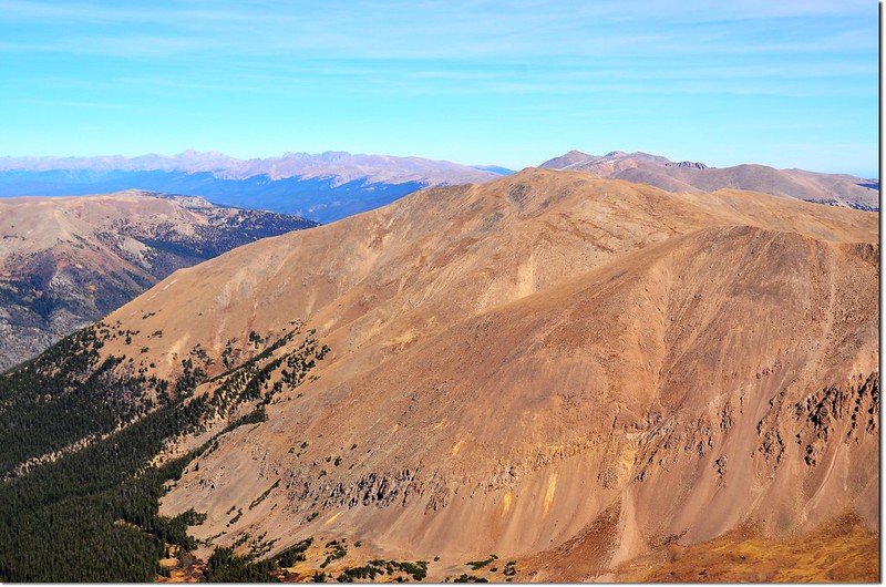
Watrous Gulch Trail一路在Watrous Gulch Creek右(東)岸緩慢上行,還算好走;峽谷盡頭右邊山頭是Woods Mountain,右側高山則是Mount Parnassus;
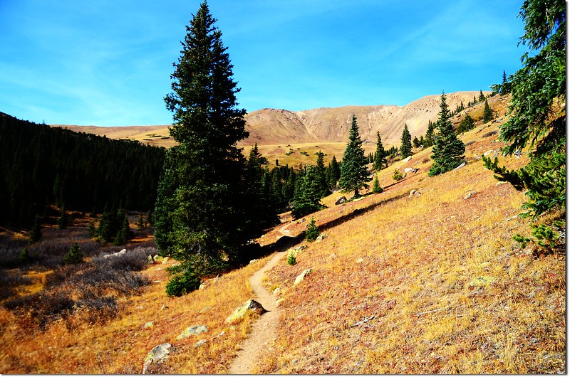
Looking towards Woods Mountain from Watrous Gulch
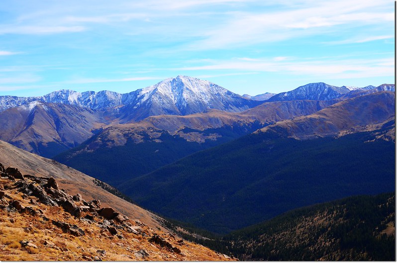
回頭南望海拔4,349公尺的Torreys Peak積雪的山頭高高矗立在山谷的另一端。
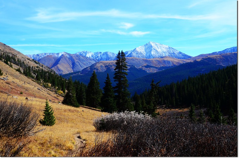
Looking towards Torreys from Watrous Gulch
09:44 眼前出現一條小小的小溪,小溪之前有不太明顯的岔路,主路徑過小溪往西北續行,右側那條不明顯的岔路入林往東北行,這是登山的路徑,小心辨認,否則容易錯過,取右入林;此地海拔約11,600呎(3,536公尺),距登山口約2.2哩(3.52公里)。
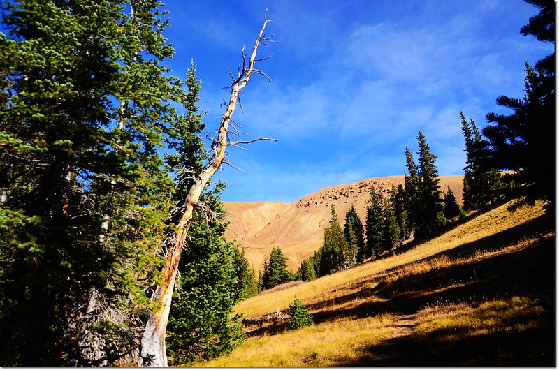
入林以後見幾處營地及石頭堆砌圍成用以生火的火堆,山徑很陡,還好地面乾燥,要是積雪未化肯定不好走。
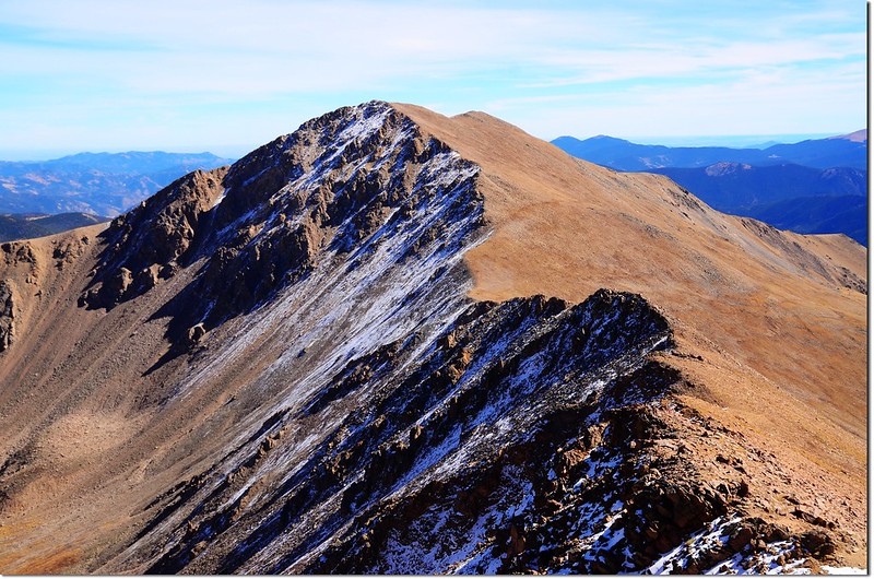
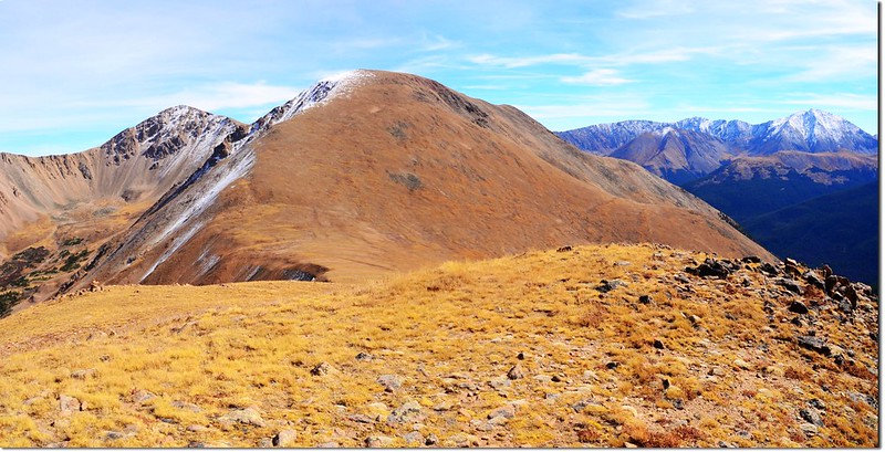
09:50 出森林線,已在Woods Mountain的山腳下,左側的山頭是Woods Mountain,她的山坡好多獨特的奇形怪狀的石柱;右側的山頭是Mount Parnassus;
Woods Mt. from out of the treeline
眼前一大片的空曠草原坡,有一條還算清晰的路徑朝東北通往Woods Mountain和Mount Parnassus之間的鞍部,沿著小徑上攀,有點吃力。
Woods Mt. from out of the treeline
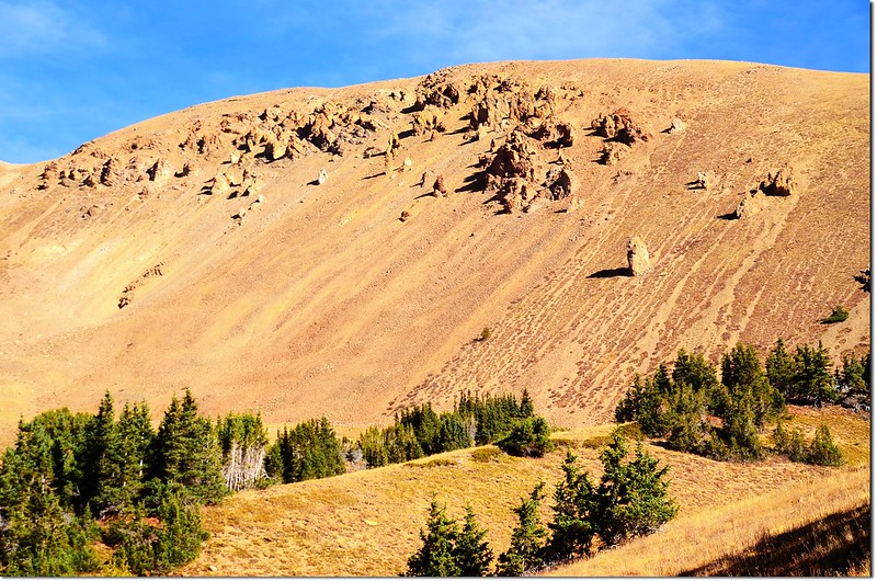
Rock Columns on Woods Mountain
Looking towards Torreys & Sniktau from Watrous Gulch
Looking down onto Watrous Gulch, taken during a hike on Parnassus 2
10:45 上抵Woods Mountain和Mount Parnassus之間的鞍部,此處海拔約12,500呎(3,810公尺),距登山口約2.8哩(4.48公里);右側(東南)是Mount Parnassus,左側(西北)是Woods Mountain。
Looking down onto Watrous Gulch from the saddle between Woods & Parnassus
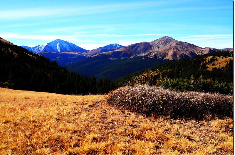
View north onto Rocky Mountains from the saddle between Woods & Parnassus
Woods Mountain as seen from the saddle between Parnassus & Woods
On the Parnassus-Woods saddle, looking toward the summit of Parnassus
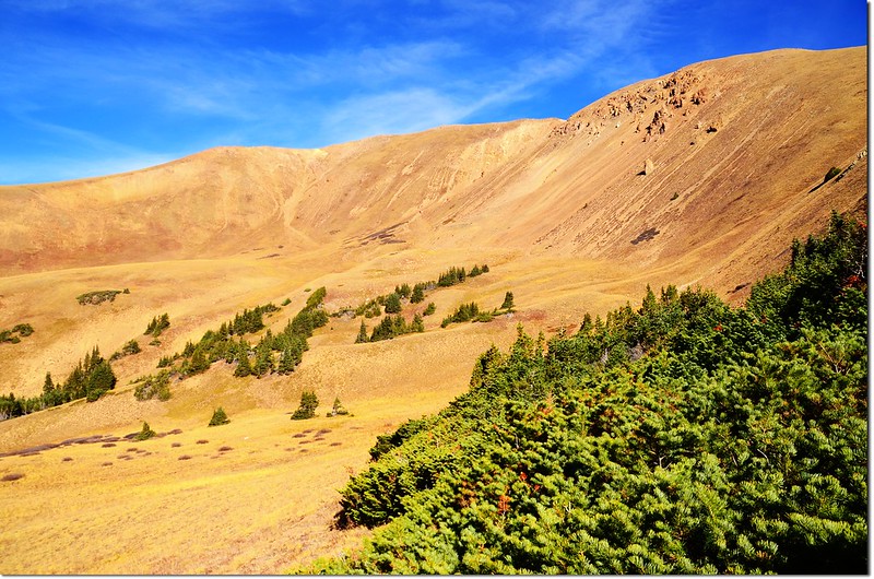
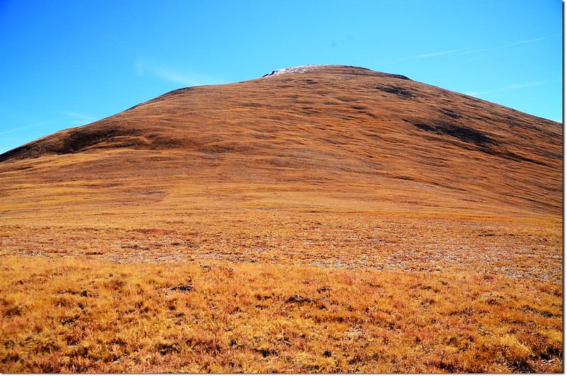
今天打算先攀登Mount Parnassus,從鞍部到Mount Parnassus山頂距離約0.8哩(1.28公里 ),還有1,075呎(328公尺 )的高度要爬升,看起來坡度蠻陡的;整個諾大的坡面無路跡可依循,只能抓準方向往上爬,距山頂約兩三百呎以上則覆蓋不少的殘雪,但無礙通行。
Looking down onto I-70 HWY from Parnassus' slopes
Woods Mountain as seen from the slopes of Parnassus
View west from near the Parnassus' summit
On Parnassus' NW slopes, looking toward It's summit
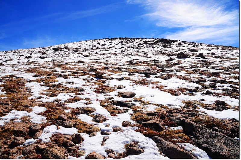
On Parnassus' NW slopes near the summit, There is still snow on the top of Parnassus
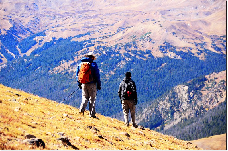
Hikers on their way down the mountain
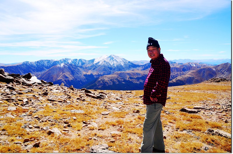
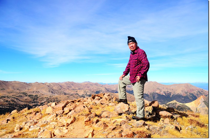
12:10 登頂Mount Parnassus,海拔13,574 呎(4,137公尺),距登山口約3.6哩(5.76公里);Mount Parnassus山頂是一蠻寬闊的平坦地形,約有一兩 個足球場大吧!
On the summit of Mount Parnassus, in the background are Grays & Torreys Peaks
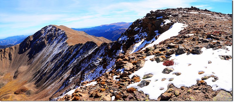
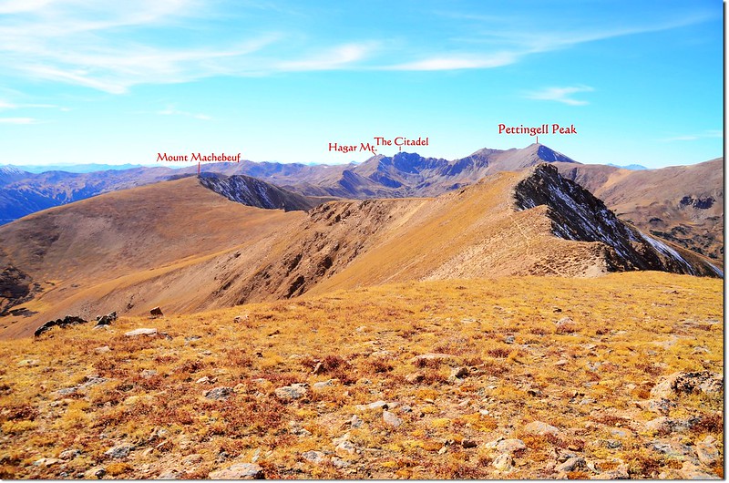
今天天空非常晴朗,加上此山頂視野本來就很寬闊,東邊緊鄰著的是直線距離約一哩路的Bard Peak,本來今天計畫順登該山的,因為時間有點匆促所以決定放棄了;
Bard Peak & Parnassus as seen from near the Parnassus' summit
Looking east to Bard Peak from the summit of Parnaussus. The connecting ridge can be seen
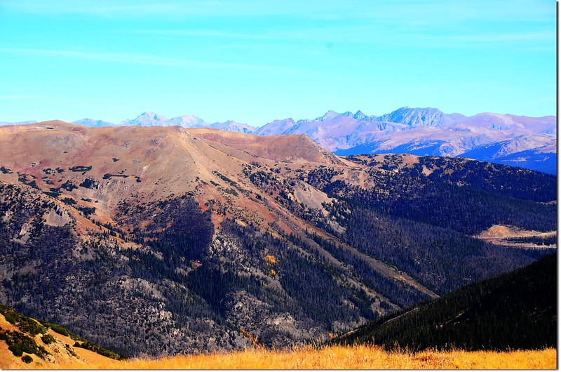
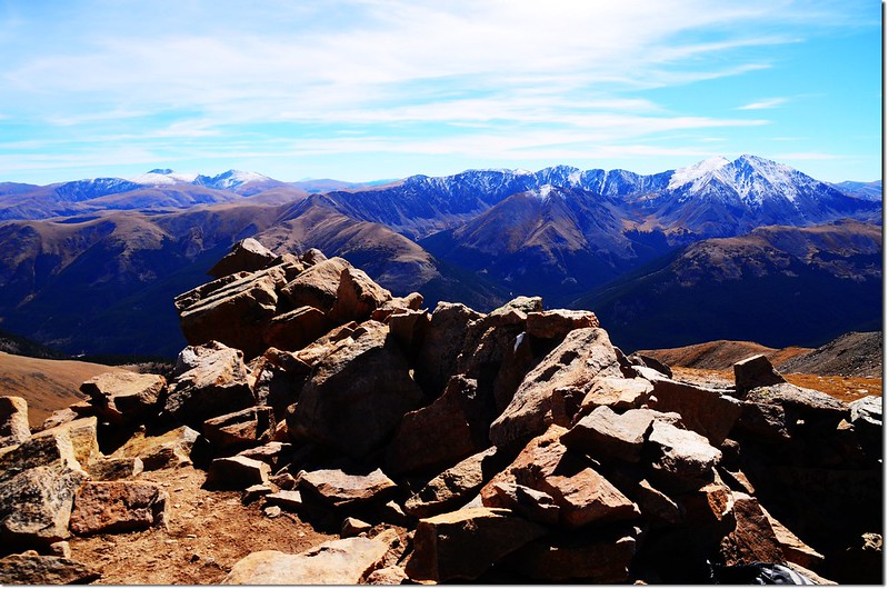
東南邊的遠方是Mount Evans、Mount Bierstadt兩座14ers以及連接兩座高山的鋸齒連稜~Sawtooth Ridge;
View southeast onto Evans & Torreys from Parnassus' summit
Mount Evans(L) & Bierstadt(R) as seen from Parnassus' summit
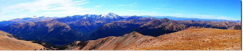
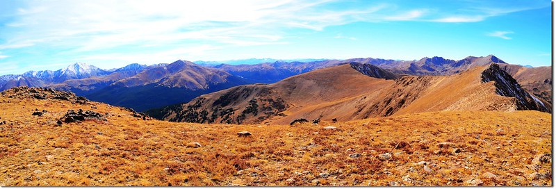
Panorama from the summit of Mount Parnassus(SE to W)
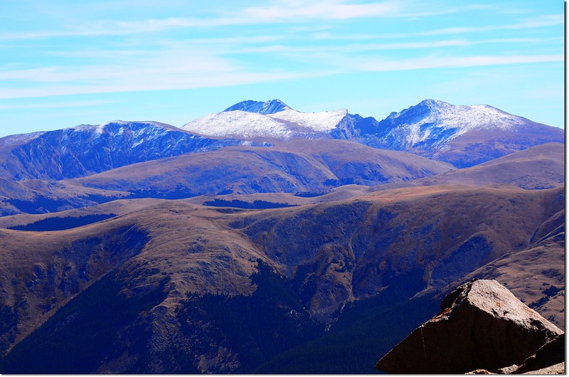
南邊俯瞰I-70州際公路,越過州際公路Grays Peak和Torreys Peak兩座14ers觸手可及;
Grays & Torreys Peaks as seen from the summit of Mount Parnassus
Grays(L) & Torreys(R) Peaks as seen from the summit of Mount Parnassus
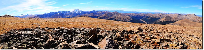
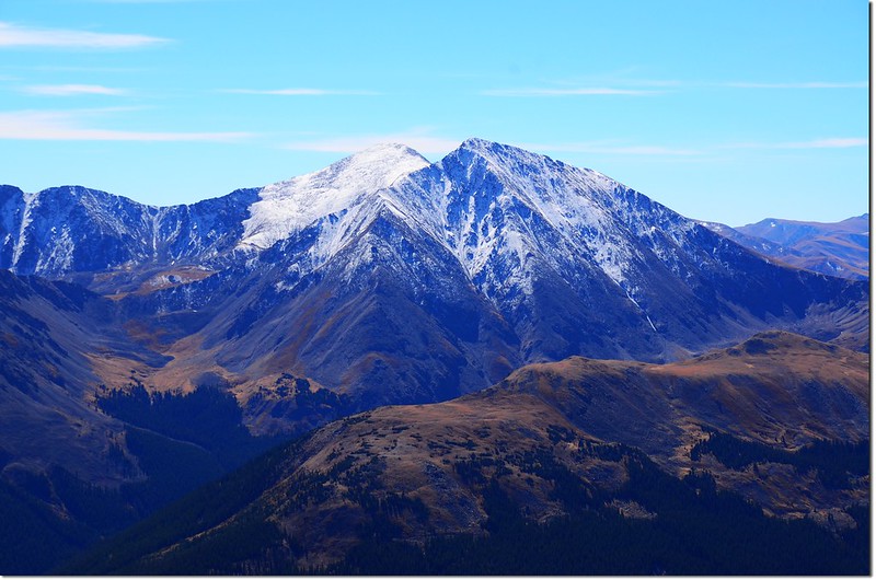
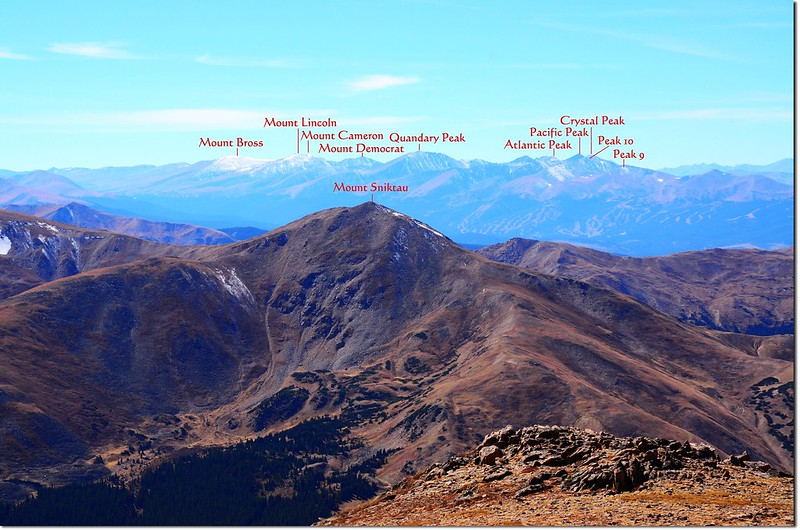
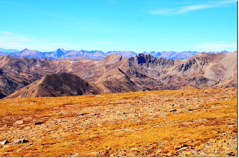
西南邊的前方山頭是另一座13ers~Mount Sniktau,在其後方遠處就是幾座14ers,包括Quandary Peak、Mount Lincoln、Mt. Cameron、Mt. Bross和Mt. Democrat;
Mount Sniktau with Quandary Peak beyond, taken from the summit of Parnassus
Grizzly Peak from the summit of Mount Parnassus
西邊仍可俯瞰I-70州際公路及隱約看到艾森豪隧道(Eisenhower-Johnson Memorial Tunnel)的東入口,在隧道的上頭即是大陸分水嶺(Continental Divide)即Loveland Loop的登山健行步道;
View west from Parnassus' summit
Mt. of the Holy Cross as seen from Parnassus' summit
西北邊俯瞰直線距離約1.2哩的Woods Mountain,下山時若體力還行則順道一訪;
Looking down onto the Wood - Parnassus saddle from the summit of Parnassus 2
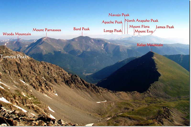
回到東北邊則是Indian Peaks Wilderness的一串高山及矗立在遠方的另一座14ers~Longs Peak,同方向向下俯瞰則是Ruby Creek Basin。
View north onto Rocky Mountains from the summit of Parnassus
13:00 下山,循原路下山。
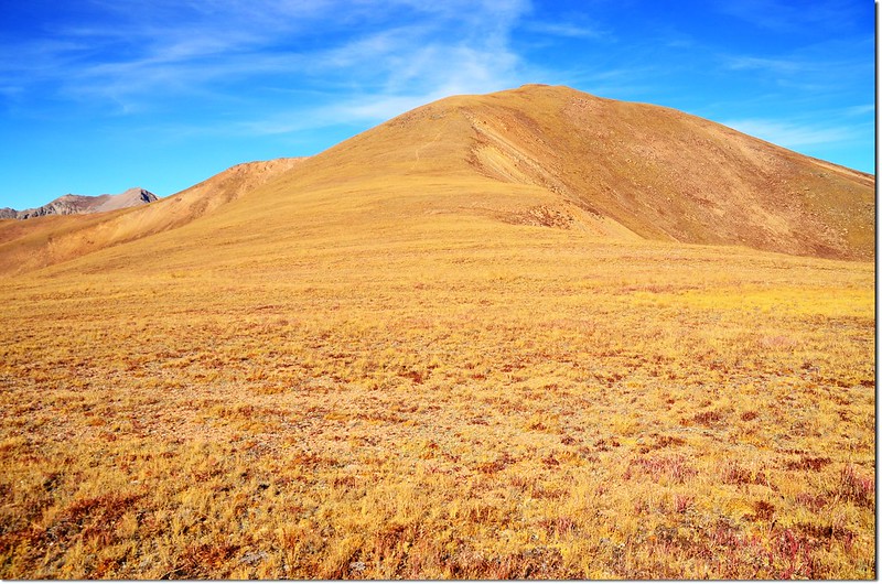
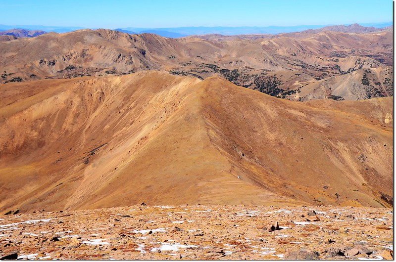
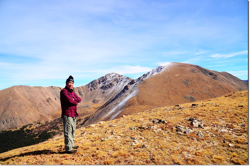
13:35 下到Woods Mountain和Mount Parnassus之間的鞍部,時間許可,決定續爬Woods Mountain,鞍部距Woods Mountain山頂約0.5哩(0.8公里),估計要再爬升近500呎,這座山的坡度要比Mount Parnassus緩坡多了,但還是有點吃力。
Looking down onto the Ruby Creek Basin from the summit of Woods Mt.
14:10 登頂Woods Mountain;Woods Mountain海拔12,940 呎(3,944公尺),距登山口約3.3哩(5.28公里);
Woods Mountain's summit
On the summit of Woods Mt., in the background are Bard & Parnassus
山頂也跟Mount Parnassus一樣是一長條狀寬闊地形,但面積顯然是小了許多,展望則和Mount Parnassus所看的差不了多少,所以稍作停留後便下山。
Bard Peak and Mount Parnassus viewed from Woods Mountain's summit
 Torreys Group & Mount Sniktau as seen from Woods Mountain
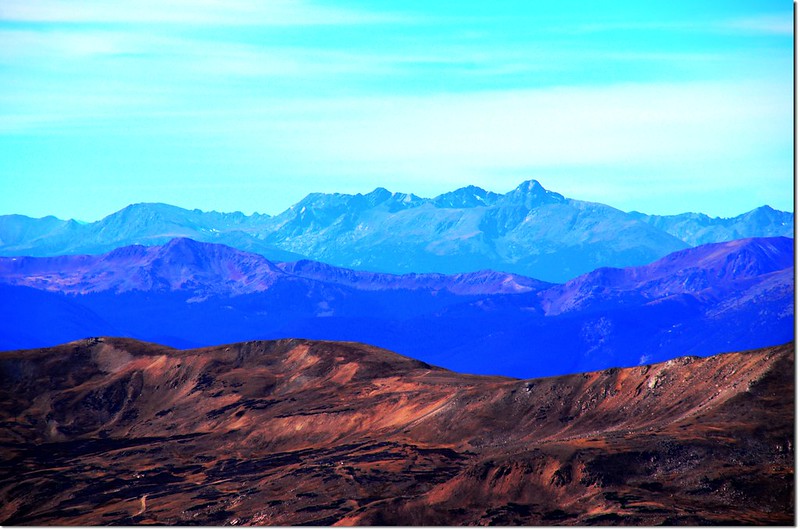
View west onto Continental Divide from Woods' summit
Loveland Pass summit as seen from Woods Mountain
Mosquito Range as seen from Woods Mountain
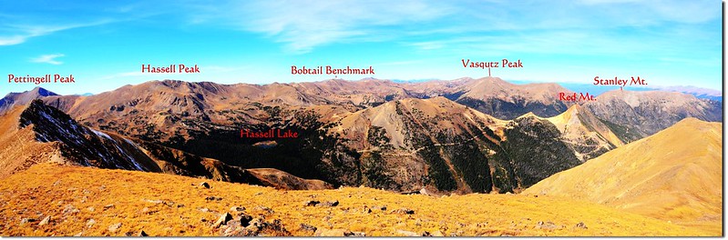
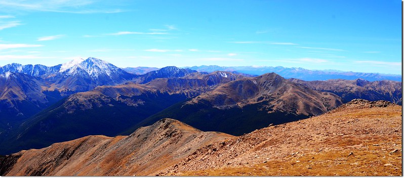
Panorama from the summit of Woods Mt, (W to N)
View southwest from Woods' summit
14:25 循原路下山。
15:08 回到峽谷尾端岔路,取左下山。
15:23 回到Bard Creek Trail岔路,取右過Watrous Gulch Creek下山。
16:04 回到登山口,有點累,但過了一天充實愉快的山上日子;拖著有點疲憊的身子開車回家。
步程簡述:
07:34 由登山口出發,Watrous Gulch Trail在Mount Machebeuf 的東南側坡往東前進,一開始數百呎的步道在松林中平緩前進,步道維護得很好。
Herman Gulch Trailhead
07:40 遇到岔路,左岔步道為Herman Gulch Trail,是通往Herman Lake的步道,右直行才是Watrous Gulch Trail往Mount Parnassus的正確步道,此處距登山口約400呎(122公尺),路牌標示已不見,我又因準備工作未紮實,取左走了約一哩多才驚覺有誤,再回頭已延誤了一個小時,多走了兩哩多,爬升約600呎,就當作熱身運動吧!
08:30 回到岔路口左轉,回到正確路線在山腰緩升東行,兩側Aspen葉子大多已掉光。
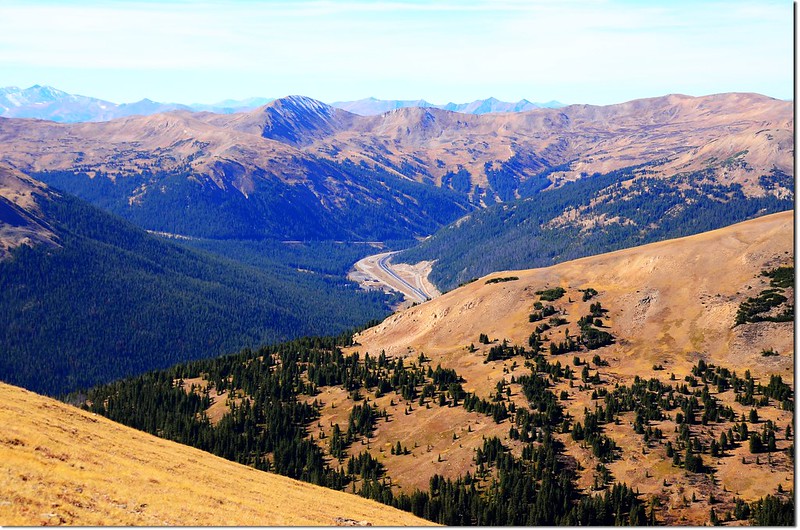
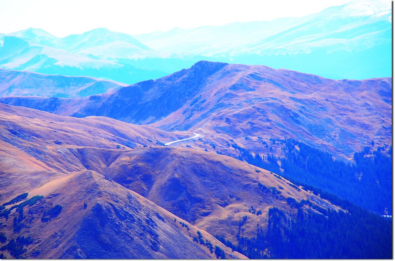
Looking down onto I-70 from Watrous Gulch Trail
Parnassus ridge taken during a hike on Parnassus
Parnassus ridge taken during a hike on Parnassus
09:25 遇到小溪Watrous Gulch Creek,跨過橫在小溪上的木板到東岸,右邊不遠處森林中有一座傾頹的木屋或shelter遺址;
Fall-Out Shelter
步道立即分成兩條,右往東續行為Bard Creek Trail (#83),左往北行是Watrous Gulch Trail(#95),取左北行沿Watrous Gulch前進;此地海拔約11,160呎(3,402公尺),距登山口約1.5哩(2.4公里)。
Watrous Gulch Trail & Bard Creek Trail junction
Watrous Gulch Trail一路在Watrous Gulch Creek右(東)岸緩慢上行,還算好走;峽谷盡頭右邊山頭是Woods Mountain,右側高山則是Mount Parnassus;
Looking towards Woods Mountain from Watrous Gulch
回頭南望海拔4,349公尺的Torreys Peak積雪的山頭高高矗立在山谷的另一端。
Looking towards Torreys from Watrous Gulch
09:44 眼前出現一條小小的小溪,小溪之前有不太明顯的岔路,主路徑過小溪往西北續行,右側那條不明顯的岔路入林往東北行,這是登山的路徑,小心辨認,否則容易錯過,取右入林;此地海拔約11,600呎(3,536公尺),距登山口約2.2哩(3.52公里)。
入林以後見幾處營地及石頭堆砌圍成用以生火的火堆,山徑很陡,還好地面乾燥,要是積雪未化肯定不好走。
09:50 出森林線,已在Woods Mountain的山腳下,左側的山頭是Woods Mountain,她的山坡好多獨特的奇形怪狀的石柱;右側的山頭是Mount Parnassus;
Woods Mt. from out of the treeline
眼前一大片的空曠草原坡,有一條還算清晰的路徑朝東北通往Woods Mountain和Mount Parnassus之間的鞍部,沿著小徑上攀,有點吃力。
Woods Mt. from out of the treeline
Rock Columns on Woods Mountain
Looking towards Torreys & Sniktau from Watrous Gulch
Looking down onto Watrous Gulch, taken during a hike on Parnassus 2
10:45 上抵Woods Mountain和Mount Parnassus之間的鞍部,此處海拔約12,500呎(3,810公尺),距登山口約2.8哩(4.48公里);右側(東南)是Mount Parnassus,左側(西北)是Woods Mountain。
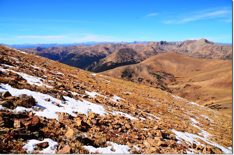
Looking down onto Watrous Gulch from the saddle between Woods & Parnassus
View north onto Rocky Mountains from the saddle between Woods & Parnassus
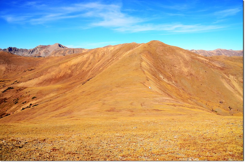
Woods Mountain as seen from the saddle between Parnassus & Woods
On the Parnassus-Woods saddle, looking toward the summit of Parnassus
今天打算先攀登Mount Parnassus,從鞍部到Mount Parnassus山頂距離約0.8哩(
Looking down onto I-70 HWY from Parnassus' slopes
Woods Mountain as seen from the slopes of Parnassus
View west from near the Parnassus' summit
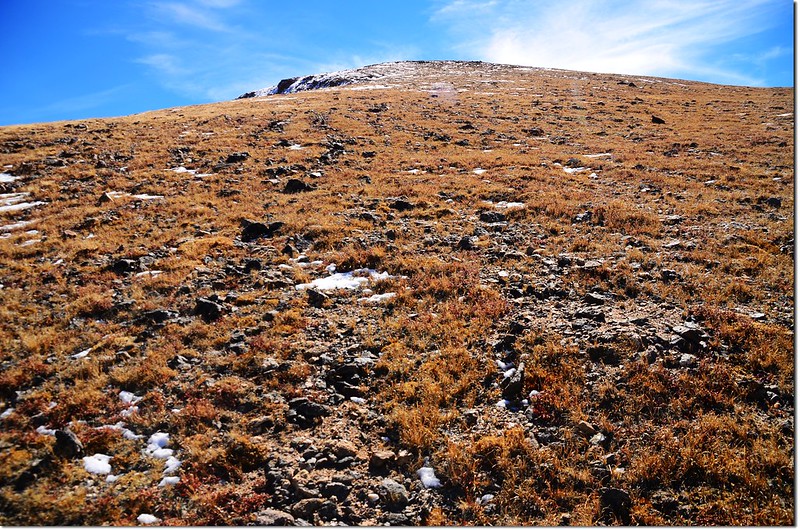
On Parnassus' NW slopes, looking toward It's summit
On Parnassus' NW slopes near the summit, There is still snow on the top of Parnassus
Hikers on their way down the mountain
12:10 登頂Mount Parnassus,海拔13,574 呎(4,137公尺),距登山口約3.6哩(5.76公里);Mount Parnassus山頂是一蠻寬闊的平坦地形,約有
On the summit of Mount Parnassus, in the background are Grays & Torreys Peaks
今天天空非常晴朗,加上此山頂視野本來就很寬闊,東邊緊鄰著的是直線距離約一哩路的Bard Peak,本來今天計畫順登該山的,因為時間有點匆促所以決定放棄了;
Bard Peak & Parnassus as seen from near the Parnassus' summit
Looking east to Bard Peak from the summit of Parnaussus. The connecting ridge can be seen
東南邊的遠方是Mount Evans、Mount Bierstadt兩座14ers以及連接兩座高山的鋸齒連稜~Sawtooth Ridge;
View southeast onto Evans & Torreys from Parnassus' summit
Mount Evans(L) & Bierstadt(R) as seen from Parnassus' summit
Panorama from the summit of Mount Parnassus(SE to W)
南邊俯瞰I-70州際公路,越過州際公路Grays Peak和Torreys Peak兩座14ers觸手可及;
Grays & Torreys Peaks as seen from the summit of Mount Parnassus
Grays(L) & Torreys(R) Peaks as seen from the summit of Mount Parnassus
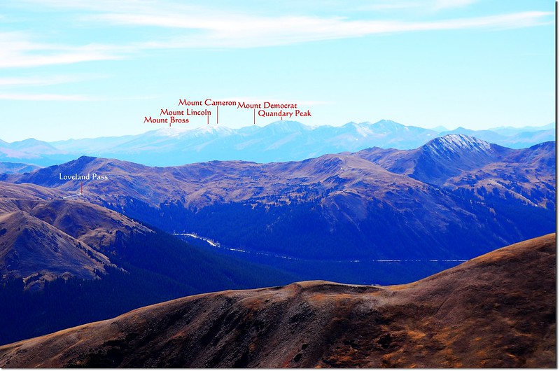
西南邊的前方山頭是另一座13ers~Mount Sniktau,在其後方遠處就是幾座14ers,包括Quandary Peak、Mount Lincoln、Mt. Cameron、Mt. Bross和Mt. Democrat;
Mount Sniktau with Quandary Peak beyond, taken from the summit of Parnassus
Grizzly Peak from the summit of Mount Parnassus
西邊仍可俯瞰I-70州際公路及隱約看到艾森豪隧道(Eisenhower-Johnson Memorial Tunnel)的東入口,在隧道的上頭即是大陸分水嶺(Continental Divide)即Loveland Loop的登山健行步道;
View west from Parnassus' summit
Mt. of the Holy Cross as seen from Parnassus' summit
西北邊俯瞰直線距離約1.2哩的Woods Mountain,下山時若體力還行則順道一訪;
Looking down onto the Wood - Parnassus saddle from the summit of Parnassus 2
回到東北邊則是Indian Peaks Wilderness的一串高山及矗立在遠方的另一座14ers~Longs Peak,同方向向下俯瞰則是Ruby Creek Basin。
View north onto Rocky Mountains from the summit of Parnassus
13:00 下山,循原路下山。
13:35 下到Woods Mountain和Mount Parnassus之間的鞍部,時間許可,決定續爬Woods Mountain,鞍部距Woods Mountain山頂約0.5哩(0.8公里),估計要再爬升近500呎,這座山的坡度要比Mount Parnassus緩坡多了,但還是有點吃力。
Looking down onto the Ruby Creek Basin from the summit of Woods Mt.
14:10 登頂Woods Mountain;Woods Mountain海拔12,940 呎(3,944公尺),距登山口約3.3哩(5.28公里);
Woods Mountain's summit
On the summit of Woods Mt., in the background are Bard & Parnassus
山頂也跟Mount Parnassus一樣是一長條狀寬闊地形,但面積顯然是小了許多,展望則和Mount Parnassus所看的差不了多少,所以稍作停留後便下山。
Bard Peak and Mount Parnassus viewed from Woods Mountain's summit
Torreys Group & Mount Sniktau as seen from Woods MountainView west onto Continental Divide from Woods' summit
Loveland Pass summit as seen from Woods Mountain
Mosquito Range as seen from Woods Mountain
Panorama from the summit of Woods Mt, (W to N)
View southwest from Woods' summit
14:25 循原路下山。
15:08 回到峽谷尾端岔路,取左下山。
15:23 回到Bard Creek Trail岔路,取右過Watrous Gulch Creek下山。
16:04 回到登山口,有點累,但過了一天充實愉快的山上日子;拖著有點疲憊的身子開車回家。
沒有留言:
張貼留言